SeismicPortal
 is the European Infrastructure
 for seismological products in :
is the European Infrastructure 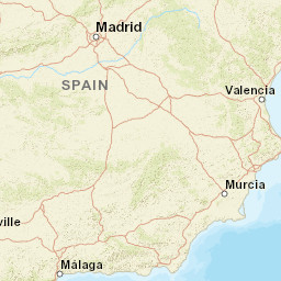


| Datetime (UTC) rmsOT_error |
Lat Smajor |
Lon Sminor |
D. (Km) AzErr |
Ndef mdist |
Nsta Mdist |
Gap | Mag1 (N) Err |
Mag2 (N) Err |
Mag3 (N) Err |
Author Quality |
|---|---|---|---|---|---|---|---|---|---|---|
| 2025-07-06T20:04:40.46Z 0.63+/- 0.67 |
36.3462 4.1 |
-2.6864 3.1 |
1 1719 |
15 0.439 |
11 1.486 |
143.8 | ml 1.5 (5) 0.3 |
() |
() |
IGN m i ke |
| Sta | Dist | EvAz | Phase | Datetime | Tres | Azim | AzRes | Slow | SRes | Def | SNR | Amp | Per | Mag1 | Mag2 |
|---|---|---|---|---|---|---|---|---|---|---|---|---|---|---|---|
| EXEJI | 0.439 | 346.8 | Sg | 2025-07-06T20:04:55.331Z | 0.8 | ||||||||||
| EXAD | 0.481 | 326.94 | Sg | 2025-07-06T20:04:56.1Z | 0.3 | ||||||||||
| EBER | 0.574 | 343.52 | Pg | 2025-07-06T20:04:51.107Z | 0.2 | ||||||||||
| EBER | 0.574 | 343.52 | Sg | 2025-07-06T20:04:59.3Z | 0.5 | 6.773e-7 | ML 1.9 | ||||||||
| EXSJO | 0.622 | 48.15 | Sg | 2025-07-06T20:05:00.251Z | -0.1 | ||||||||||
| ENIJ | 0.733 | 31.56 | Pg | 2025-07-06T20:04:53.495Z | -0.3 | ||||||||||
| ENIJ | 0.733 | 31.56 | Sg | 2025-07-06T20:05:03.492Z | -0.4 | ||||||||||
| WCAL | 0.881 | 7.03 | Sg | 2025-07-06T20:05:07.906Z | -0.7 | ||||||||||
| ELGU | 0.918 | 304.81 | Sg | 2025-07-06T20:05:08.896Z | -0.9 | ||||||||||
| EQTA | 1.049 | 325.01 | Pg | 2025-07-06T20:04:59.873Z | 0.3 | ||||||||||
| EQTA | 1.049 | 325.01 | Sg | 2025-07-06T20:05:12.702Z | -1.3 | ||||||||||
| WMELI | 1.049 | 191.94 | Sg | 2025-07-06T20:05:13.932Z | -0.1 | ||||||||||
| EQES | 1.486 | 348.17 | Pg | 2025-07-06T20:05:08.122Z | 0.6 | ||||||||||
| EQES | 1.486 | 348.17 | Sn | 2025-07-06T20:05:26.585Z | 0 | 3.4299999999999996e-8 | ML 1.2 | ||||||||
| Sta | Dist | EvAz | Phase | Datetime | Tres | Azim | AzRes | Slow | SRes | Def | SNR | Amp | Per | Mag1 | Mag2 |
| Centroid | Nodal Plan 1 | Nodal Plan 2 | Tensor | Moment Inf. | |||||||||||||||||
|---|---|---|---|---|---|---|---|---|---|---|---|---|---|---|---|---|---|---|---|---|---|
| Auth | Datetime | Lat | Lon | Depth | Mw | Strike | Dip | Rake | Strike | Dip | Rake | Mrr | Mtt | Mpp | Mrt | Mrp | Mtp | %DC | %ISO | %CLVD | |
| Auth | Datetime UTC | lat | lon | Depth | Mw | Strike | Dip | Rake | Strike | Dip | Rake | Mrr | Mtt | Mpp | Mrt | Mrp | Mtp | %DC | %ISO | %CLVD | |

