SeismicPortal
 is the European Infrastructure
 for seismological products in :
is the European Infrastructure 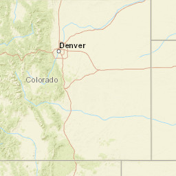


| Datetime (UTC) rmsOT_error |
Lat Smajor |
Lon Sminor |
D. (Km) AzErr |
Ndef mdist |
Nsta Mdist |
Gap | Mag1 (N) Err |
Mag2 (N) Err |
Mag3 (N) Err |
Author Quality |
|---|---|---|---|---|---|---|---|---|---|---|
| 2025-07-05T20:53:00.611Z 0.76+/- 1.55 |
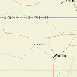
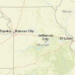
39.1303 10.23 |
-100.0679 3.02 |
10 2261.996 |
16 0.408 |
15 4.862 |
103.6 | ml 2.7 (78) 0.06 |
() |
() |
NEIC m i ke |
| Sta | Dist | EvAz | Phase | Datetime | Tres | Azim | AzRes | Slow | SRes | Def | SNR | Amp | Per | Mag1 | Mag2 |
|---|---|---|---|---|---|---|---|---|---|---|---|---|---|---|---|
| CBKS | 0.408 | 140.66 | Pg | 2025-07-05T20:53:08.43Z | -0.89 | ||||||||||
| CBKS | 0.408 | 140.66 | Sg | 2025-07-05T20:53:15.47Z | 0.72 | ||||||||||
| R32B | 1.275 | 123.27 | Pn | 2025-07-05T20:53:22.76Z | -2.42 | ||||||||||
| R32B | 1.275 | 123.27 | Sg | 2025-07-05T20:53:37.96Z | -4.36 | ||||||||||
| KS26 | 1.938 | 122.71 | Pn | 2025-07-05T20:53:32.58Z | -1.72 | ||||||||||
| KSCO | 1.995 | 267.38 | Pn | 2025-07-05T20:53:35.6Z | -0.14 | ||||||||||
| FREE | 2.285 | 163.77 | Pn | 2025-07-05T20:53:39.53Z | 0.45 | ||||||||||
| OGNE | 2.358 | 320.86 | Pn | 2025-07-05T20:53:39.18Z | -0.97 | ||||||||||
| KS01 | 2.685 | 136.6 | Pn | 2025-07-05T20:53:43.84Z | -0.72 | ||||||||||
| KSU1 | 2.69 | 89.53 | Pn | 2025-07-05T20:53:42.94Z | -1.68 | ||||||||||
| CROK | 3.097 | 147.14 | Pn | 2025-07-05T20:53:49.74Z | -0.5 | ||||||||||
| BLOK | 3.268 | 135.48 | Pn | 2025-07-05T20:53:52.4Z | -0.53 | ||||||||||
| SC19 | 3.399 | 148.03 | Pn | 2025-07-05T20:53:53.76Z | -0.62 | ||||||||||
| K30B | 3.556 | 5.41 | Pn | 2025-07-05T20:53:56.6Z | -0.52 | ||||||||||
| N35B | 3.813 | 61.64 | Pn | 2025-07-05T20:54:00.9Z | 0.03 | ||||||||||
| SMNL | 4.74 | 142.79 | Pn | 2025-07-05T20:54:11.18Z | -1.63 | ||||||||||
| X34A | 4.862 | 157.69 | Pn | 2025-07-05T20:54:13.33Z | -1.17 | ||||||||||
| Sta | Dist | EvAz | Phase | Datetime | Tres | Azim | AzRes | Slow | SRes | Def | SNR | Amp | Per | Mag1 | Mag2 |
| Centroid | Nodal Plan 1 | Nodal Plan 2 | Tensor | Moment Inf. | |||||||||||||||||
|---|---|---|---|---|---|---|---|---|---|---|---|---|---|---|---|---|---|---|---|---|---|
| Auth | Datetime | Lat | Lon | Depth | Mw | Strike | Dip | Rake | Strike | Dip | Rake | Mrr | Mtt | Mpp | Mrt | Mrp | Mtp | %DC | %ISO | %CLVD | |
| Auth | Datetime UTC | lat | lon | Depth | Mw | Strike | Dip | Rake | Strike | Dip | Rake | Mrr | Mtt | Mpp | Mrt | Mrp | Mtp | %DC | %ISO | %CLVD | |
