SeismicPortal
 is the European Infrastructure
 for seismological products in :
is the European Infrastructure 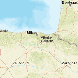


| Datetime (UTC) rmsOT_error |
Lat Smajor |
Lon Sminor |
D. (Km) AzErr |
Ndef mdist |
Nsta Mdist |
Gap | Mag1 (N) Err |
Mag2 (N) Err |
Mag3 (N) Err |
Author Quality |
|---|---|---|---|---|---|---|---|---|---|---|
| 2025-07-01T01:28:46.79Z 0.52+/- 0.6 |
43.104 6.6 |
-1.1457 4.1 |
10.8 123.6 |
15 0.243 |
9 1.106 |
159.3 | ml 1.6 (8) 0.3 |
() |
() |
IGN m i ke |
| Sta | Dist | EvAz | Phase | Datetime | Tres | Azim | AzRes | Slow | SRes | Def | SNR | Amp | Per | Mag1 | Mag2 |
|---|---|---|---|---|---|---|---|---|---|---|---|---|---|---|---|
| EORO | 0.243 | 209.68 | Pg | 2025-07-01T01:28:51.553Z | 0 | ||||||||||
| EORO | 0.243 | 209.68 | Sg | 2025-07-01T01:28:55.179Z | 0 | 0.0000012467 | ML 1.7 | ||||||||
| EALK | 0.288 | 293.74 | Pg | 2025-07-01T01:28:52.501Z | 0.2 | ||||||||||
| EALK | 0.288 | 293.74 | Sg | 2025-07-01T01:28:56.461Z | 0 | 6.084e-7 | ML 1.5 | ||||||||
| ATE | 0.327 | 93 | Pg | 2025-07-01T01:28:52.836Z | -0.2 | ||||||||||
| ATE | 0.327 | 93 | Sg | 2025-07-01T01:28:57.521Z | -0.1 | ||||||||||
| OIAR | 0.53 | 292.21 | Pg | 2025-07-01T01:28:56.852Z | 0.3 | ||||||||||
| OIAR | 0.53 | 292.21 | Sg | 2025-07-01T01:29:03.601Z | -0.3 | 0.0000016967 | ML 2.3 | ||||||||
| ABAL | 0.714 | 265.02 | Pg | 2025-07-01T01:29:00.589Z | 0.7 | ||||||||||
| ABAL | 0.714 | 265.02 | Sg | 2025-07-01T01:29:10.35Z | 0.7 | 1.833e-7 | ML 1.5 | ||||||||
| BIDA | 0.737 | 274.71 | Pg | 2025-07-01T01:29:00.422Z | 0.2 | ||||||||||
| BIDA | 0.737 | 274.71 | Sg | 2025-07-01T01:29:09.458Z | -0.9 | 3.0010000000000005e-7 | ML 1.7 | ||||||||
| ALDA | 0.938 | 248.96 | Sg | 2025-07-01T01:29:15.593Z | -1.1 | 8.290000000000001e-8 | ML 1.3 | ||||||||
| AXPU | 0.954 | 259.75 | Sg | 2025-07-01T01:29:17.44Z | -0.1 | 8.520000000000001e-8 | ML 1.3 | ||||||||
| OKIN | 1.106 | 253.35 | Sg | 2025-07-01T01:29:22.733Z | 0.8 | 7.57e-8 | ML 1.3 | ||||||||
| Sta | Dist | EvAz | Phase | Datetime | Tres | Azim | AzRes | Slow | SRes | Def | SNR | Amp | Per | Mag1 | Mag2 |
| Centroid | Nodal Plan 1 | Nodal Plan 2 | Tensor | Moment Inf. | |||||||||||||||||
|---|---|---|---|---|---|---|---|---|---|---|---|---|---|---|---|---|---|---|---|---|---|
| Auth | Datetime | Lat | Lon | Depth | Mw | Strike | Dip | Rake | Strike | Dip | Rake | Mrr | Mtt | Mpp | Mrt | Mrp | Mtp | %DC | %ISO | %CLVD | |
| Auth | Datetime UTC | lat | lon | Depth | Mw | Strike | Dip | Rake | Strike | Dip | Rake | Mrr | Mtt | Mpp | Mrt | Mrp | Mtp | %DC | %ISO | %CLVD | |

