SeismicPortal
 is the European Infrastructure
 for seismological products in :
is the European Infrastructure 

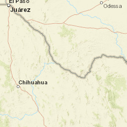


| Datetime (UTC) rmsOT_error |
Lat Smajor |
Lon Sminor |
D. (Km) AzErr |
Ndef mdist |
Nsta Mdist |
Gap | Mag1 (N) Err |
Mag2 (N) Err |
Mag3 (N) Err |
Author Quality |
|---|---|---|---|---|---|---|---|---|---|---|
| 2025-06-30T21:10:49.34269Z 0.5+/- 0.82 |
32 5.93 |
-102.23 2.74 |
5.4 143.61193847656253.6680378913879395 |
14 0.02 |
8 0.599 |
118.2 | ml 2 (7) 0.2 |
() |
() |
TX a i ke |
| Sta | Dist | EvAz | Phase | Datetime | Tres | Azim | AzRes | Slow | SRes | Def | SNR | Amp | Per | Mag1 | Mag2 |
|---|---|---|---|---|---|---|---|---|---|---|---|---|---|---|---|
| MB07 | 0.02 | 272.93 | P | 2025-06-30T21:10:49.798Z | -0.514 | 1107.8659621156833 | 0.020925577893341495 | ML 2.159984106963955 | |||||||
| MB07 | 0.02 | 272.93 | S | 2025-06-30T21:10:50.808Z | -0.435 | ||||||||||
| MID03 | 0.02 | 53.37 | P | 2025-06-30T21:10:49.67Z | -0.666 | 211.25341521196555 | 0.018230458063062314 | ML 2.108655622872817 | |||||||
| MID03 | 0.02 | 53.37 | S | 2025-06-30T21:10:50.63Z | -0.654 | ||||||||||
| MID01 | 0.054 | 181.99 | P | 2025-06-30T21:10:50.47Z | -0.471 | 146.926776883143 | 0.0037003430458491344 | ML 1.7026342207472325 | |||||||
| MID01 | 0.054 | 181.99 | S | 2025-06-30T21:10:52.4Z | -0.289 | ||||||||||
| OG02 | 0.092 | 240.7 | P | 2025-06-30T21:10:51.588Z | -0.044 | 372.4433780633246 | 0.005638496919736875 | ML 2.209692548656232 | |||||||
| OG02 | 0.092 | 240.7 | S | 2025-06-30T21:10:53.918Z | 0.396 | ||||||||||
| MB18 | 0.096 | 31.11 | P | 2025-06-30T21:10:51.68Z | -0.033 | 182.87679110846346 | 0.002892363615073303 | ML 1.953620124398454 | |||||||
| MB18 | 0.096 | 31.11 | S | 2025-06-30T21:10:54.8Z | 0.418 | ||||||||||
| OG04 | 0.131 | 237.39 | P | 2025-06-30T21:10:52.6Z | 0.253 | 165.3557843903989 | 0.0020455886476865885 | ML 2.037498170277263 | |||||||
| OG04 | 0.131 | 237.39 | S | 2025-06-30T21:10:55.52Z | 0.764 | ||||||||||
| MBBB2 | 0.143 | 68.03 | S | 2025-06-30T21:10:55.92Z | 0.771 | ||||||||||
| MB13 | 0.599 | 57.51 | P | 2025-06-30T21:11:01.4Z | 0.502 | 3.5921385186946235 | 0.00009506422665133951 | ML 1.701980957239374 | |||||||
| Sta | Dist | EvAz | Phase | Datetime | Tres | Azim | AzRes | Slow | SRes | Def | SNR | Amp | Per | Mag1 | Mag2 |
| Centroid | Nodal Plan 1 | Nodal Plan 2 | Tensor | Moment Inf. | |||||||||||||||||
|---|---|---|---|---|---|---|---|---|---|---|---|---|---|---|---|---|---|---|---|---|---|
| Auth | Datetime | Lat | Lon | Depth | Mw | Strike | Dip | Rake | Strike | Dip | Rake | Mrr | Mtt | Mpp | Mrt | Mrp | Mtp | %DC | %ISO | %CLVD | |
| Auth | Datetime UTC | lat | lon | Depth | Mw | Strike | Dip | Rake | Strike | Dip | Rake | Mrr | Mtt | Mpp | Mrt | Mrp | Mtp | %DC | %ISO | %CLVD | |

