SeismicPortal
 is the European Infrastructure
 for seismological products in :
is the European Infrastructure 

| Datetime (UTC) rmsOT_error |
Lat Smajor |
Lon Sminor |
D. (Km) AzErr |
Ndef mdist |
Nsta Mdist |
Gap | Mag1 (N) Err |
Mag2 (N) Err |
Mag3 (N) Err |
Author Quality |
|---|---|---|---|---|---|---|---|---|---|---|
| 2025-06-19T23:06:36.0Z 0.27+/- 0.38 |
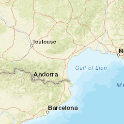
41.9938 2.26 |
15.5587 0.39 |
1 61.2 |
15 0.331 |
8 1.539 |
255.6 | ml 2 (14) 0.2 |
() |
() |
INGV m i ke |
| Sta | Dist | EvAz | Phase | Datetime | Tres | Azim | AzRes | Slow | SRes | Def | SNR | Amp | Per | Mag1 | Mag2 |
|---|---|---|---|---|---|---|---|---|---|---|---|---|---|---|---|
| OT16 | 0.331 | 241.34 | P | 2025-06-19T23:06:43.34Z | 0.01 | ||||||||||
| OT16 | 0.331 | 241.34 | S | 2025-06-19T23:06:48.62Z | -0.09 | ||||||||||
| MSAG | 0.385 | 136.9 | P | 2025-06-19T23:06:44.2Z | -0.34 | ||||||||||
| MSAG | 0.385 | 136.9 | S | 2025-06-19T23:06:51.7Z | 0.27 | ||||||||||
| SGTA | 0.87 | 189.68 | P | 2025-06-19T23:06:53.88Z | 0.28 | ||||||||||
| SGTA | 0.87 | 189.68 | S | 2025-06-19T23:07:06.18Z | -0.3 | ||||||||||
| MRVN | 1.047 | 152.61 | P | 2025-06-19T23:06:56.44Z | -0.19 | ||||||||||
| MRVN | 1.047 | 152.61 | S | 2025-06-19T23:07:11.45Z | -0.26 | ||||||||||
| PALZ | 1.091 | 163.83 | P | 2025-06-19T23:06:57.11Z | -0.27 | ||||||||||
| PALZ | 1.091 | 163.83 | S | 2025-06-19T23:07:13.23Z | 0.2 | ||||||||||
| MCRV | 1.245 | 193.79 | S | 2025-06-19T23:07:12.94Z | -3.14 | ||||||||||
| AMUR | 1.34 | 143.76 | P | 2025-06-19T23:07:01.38Z | -0.23 | ||||||||||
| AMUR | 1.34 | 143.76 | S | 2025-06-19T23:07:19.85Z | -0.51 | ||||||||||
| PTRP | 1.518 | 165.39 | P | 2025-06-19T23:07:05.61Z | 0.91 | ||||||||||
| MIGL | 1.539 | 154.12 | P | 2025-06-19T23:07:05.25Z | 0.22 | ||||||||||
| MIGL | 1.539 | 154.12 | S | 2025-06-19T23:07:26.48Z | 0.2 | ||||||||||
| Sta | Dist | EvAz | Phase | Datetime | Tres | Azim | AzRes | Slow | SRes | Def | SNR | Amp | Per | Mag1 | Mag2 |
| Centroid | Nodal Plan 1 | Nodal Plan 2 | Tensor | Moment Inf. | |||||||||||||||||
|---|---|---|---|---|---|---|---|---|---|---|---|---|---|---|---|---|---|---|---|---|---|
| Auth | Datetime | Lat | Lon | Depth | Mw | Strike | Dip | Rake | Strike | Dip | Rake | Mrr | Mtt | Mpp | Mrt | Mrp | Mtp | %DC | %ISO | %CLVD | |
| Auth | Datetime UTC | lat | lon | Depth | Mw | Strike | Dip | Rake | Strike | Dip | Rake | Mrr | Mtt | Mpp | Mrt | Mrp | Mtp | %DC | %ISO | %CLVD | |

