SeismicPortal
 is the European Infrastructure
 for seismological products in :
is the European Infrastructure 

| Datetime (UTC) rmsOT_error |
Lat Smajor |
Lon Sminor |
D. (Km) AzErr |
Ndef mdist |
Nsta Mdist |
Gap | Mag1 (N) Err |
Mag2 (N) Err |
Mag3 (N) Err |
Author Quality |
|---|---|---|---|---|---|---|---|---|---|---|
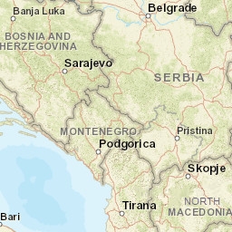
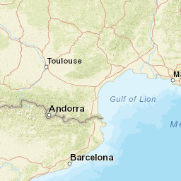
| 2025-06-17T11:53:33.0Z +/- |
42.279 |
19.306 |
22 |
24 0.129 |
11 95.969 |
93.2 | ml 1.9 () |
() |
() |
MSO m i ke |
| Sta | Dist | EvAz | Phase | Datetime | Tres | Azim | AzRes | Slow | SRes | Def | SNR | Amp | Per | Mag1 | Mag2 |
|---|---|---|---|---|---|---|---|---|---|---|---|---|---|---|---|
| DRME | 0.129 | 224.46 | P | 2025-06-17T11:53:38.4Z | 0 | ||||||||||
| DRME | 0.129 | 224.46 | S | 2025-06-17T11:53:42.0Z | 0 | ||||||||||
| PDG | 0.154 | 347.55 | P | 2025-06-17T11:53:38.5Z | 0 | ||||||||||
| ULC | 0.318 | 188.28 | P | 2025-06-17T11:53:40.7Z | 0 | ||||||||||
| ULC | 0.318 | 188.28 | S | 2025-06-17T11:53:46.0Z | 0 | ||||||||||
| CEME | 0.39 | 313.4 | P | 2025-06-17T11:53:41.9Z | 0 | ||||||||||
| CEME | 0.39 | 313.4 | S | 2025-06-17T11:53:48.0Z | 0 | ||||||||||
| NKME | 0.553 | 331.96 | P | 2025-06-17T11:53:44.4Z | 0 | ||||||||||
| NKME | 0.553 | 331.96 | P | 2025-06-17T11:53:44.4Z | 0 | ||||||||||
| PVY | 0.577 | 56.66 | P | 2025-06-17T11:53:45.2Z | 0 | ||||||||||
| PVY | 0.577 | 56.66 | P | 2025-06-17T11:53:45.2Z | 0 | ||||||||||
| PVY | 0.577 | 56.66 | S | 2025-06-17T11:53:54.0Z | 0 | 3.8e-8 | 1 | ||||||||
| PVY | 0.577 | 56.66 | S | 2025-06-17T11:53:54.0Z | 0 | ||||||||||
| KOME | 0.591 | 15.07 | P | 2025-06-17T11:53:45.3Z | 0 | ||||||||||
| BRY | 0.841 | 317.94 | P | 2025-06-17T11:53:49.6Z | 0 | ||||||||||
| BRY | 0.841 | 317.94 | P | 2025-06-17T11:53:49.6Z | 0 | ||||||||||
| BRY | 0.841 | 317.94 | S | 2025-06-17T11:54:03.0Z | 0 | 4.8e-8 | 1 | ||||||||
| BRY | 0.841 | 317.94 | S | 2025-06-17T11:54:03.0Z | 0 | ||||||||||
| BUM | 95.969 | 95.11 | P | 2025-06-17T11:53:40.9Z | 0 | ||||||||||
| BUM | 95.969 | 95.11 | S | 2025-06-17T11:53:46.0Z | 0 | 5.2e-8 | 1 | ||||||||
| Sta | Dist | EvAz | Phase | Datetime | Tres | Azim | AzRes | Slow | SRes | Def | SNR | Amp | Per | Mag1 | Mag2 |
| Centroid | Nodal Plan 1 | Nodal Plan 2 | Tensor | Moment Inf. | |||||||||||||||||
|---|---|---|---|---|---|---|---|---|---|---|---|---|---|---|---|---|---|---|---|---|---|
| Auth | Datetime | Lat | Lon | Depth | Mw | Strike | Dip | Rake | Strike | Dip | Rake | Mrr | Mtt | Mpp | Mrt | Mrp | Mtp | %DC | %ISO | %CLVD | |
| Auth | Datetime UTC | lat | lon | Depth | Mw | Strike | Dip | Rake | Strike | Dip | Rake | Mrr | Mtt | Mpp | Mrt | Mrp | Mtp | %DC | %ISO | %CLVD | |

