SeismicPortal
 is the European Infrastructure
 for seismological products in :
is the European Infrastructure 

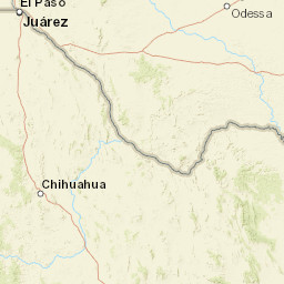


| Datetime (UTC) rmsOT_error |
Lat Smajor |
Lon Sminor |
D. (Km) AzErr |
Ndef mdist |
Nsta Mdist |
Gap | Mag1 (N) Err |
Mag2 (N) Err |
Mag3 (N) Err |
Author Quality |
|---|---|---|---|---|---|---|---|---|---|---|
| 2025-06-14T11:17:03.608401Z 0.9+/- 0.42 |
31.816 8.01 |
-103.307 2.71 |
0.5 165.906585693359382.5762689113616943 |
28 0.122 |
19 0.88 |
201.4 | ml 2 (13) 0.3 |
() |
() |
TX a i ke |
| Sta | Dist | EvAz | Phase | Datetime | Tres | Azim | AzRes | Slow | SRes | Def | SNR | Amp | Per | Mag1 | Mag2 |
|---|---|---|---|---|---|---|---|---|---|---|---|---|---|---|---|
| PB54 | 0.122 | 309.93 | P | 2025-06-14T11:17:06.16Z | 0.026 | 83.90111299552484 | 0.004013251542611325 | ML 2.2077771509488446 | |||||||
| PB54 | 0.122 | 309.93 | S | 2025-06-14T11:17:07.55Z | 0.425 | ||||||||||
| PB51 | 0.139 | 332.82 | P | 2025-06-14T11:17:05.65Z | -0.815 | 65.28253589135164 | 0.0014144956969233053 | ML 1.8760783477895722 | |||||||
| PB51 | 0.139 | 332.82 | S | 2025-06-14T11:17:06.81Z | -0.892 | ||||||||||
| NMP51 | 0.212 | 332.6 | P | 2025-06-14T11:17:06.43Z | -1.41 | 500.9946132518114 | 0.009877960194166072 | ML 3.011738192763616 | |||||||
| NMP41 | 0.31 | 307.52 | P | 2025-06-14T11:17:09.15Z | -0.551 | 20.975453948187468 | 0.0005723159141366675 | ML 2.0318503098429193 | |||||||
| WB10 | 0.371 | 288.01 | P | 2025-06-14T11:17:10.3915Z | -0.463 | 8.413431340345944 | 0.003111142404980138 | ML 2.888342461584666 | |||||||
| WB06 | 0.394 | 297.42 | P | 2025-06-14T11:17:12.2195Z | 0.924 | 5.07949226074113 | 0.0003718917197725826 | ML 2.007110163705679 | |||||||
| NMP31 | 0.425 | 301.2 | P | 2025-06-14T11:17:12.39Z | 0.519 | 11.10072165449617 | 0.0005867637042847764 | ML 2.2555163996781844 | |||||||
| NMP31 | 0.425 | 301.2 | S | 2025-06-14T11:17:18.43Z | 1.334 | ||||||||||
| WB11 | 0.434 | 285 | P | 2025-06-14T11:17:13.15Z | 0.947 | 2.9558506843390657 | 0.0007186390612106007 | ML 2.3588662435634915 | |||||||
| WB09 | 0.447 | 289.37 | P | 2025-06-14T11:17:13.2385Z | 0.941 | 6.442394486796043 | 0.0002749871906871975 | ML 1.9613783963607108 | |||||||
| NGL02 | 0.469 | 28.32 | S | 2025-06-14T11:17:17.503Z | -1.082 | ||||||||||
| NGL01 | 0.473 | 33.79 | P | 2025-06-14T11:17:12.5Z | -0.791 | 12.249677454969296 | 0.00008721911727362173 | ML 1.5015801227574321 | |||||||
| NGL01 | 0.473 | 33.79 | S | 2025-06-14T11:17:18.175Z | -0.528 | ||||||||||
| NMP02 | 0.545 | 300.19 | P | 2025-06-14T11:17:15.0Z | 0.857 | 8.26043375260016 | 0.0002421656908332522 | ML 2.040213300278542 | |||||||
| NMP02 | 0.545 | 300.19 | S | 2025-06-14T11:17:22.8Z | 1.757 | ||||||||||
| NMP23 | 0.548 | 309.85 | P | 2025-06-14T11:17:15.435Z | 1.228 | 14.27032773910257 | 0.00033623980480029824 | ML 2.186996962425069 | |||||||
| NMP23 | 0.548 | 309.85 | S | 2025-06-14T11:17:22.25Z | 0.87 | ||||||||||
| NM02 | 0.66 | 312.76 | S | 2025-06-14T11:17:24.32Z | -0.53 | ||||||||||
| NM03 | 0.711 | 337.12 | S | 2025-06-14T11:17:26.23Z | -0.306 | ||||||||||
| ODSA | 0.712 | 64.6 | P | 2025-06-14T11:17:18.65Z | 0.736 | 6.227340650713941 | 0.0000567532640183768 | ML 1.593897647511345 | |||||||
| ODSA | 0.712 | 64.6 | S | 2025-06-14T11:17:27.915Z | 1.334 | ||||||||||
| SA04 | 0.81 | 266.01 | P | 2025-06-14T11:17:18.469Z | -0.69 | 3.5886636106317775 | 0.00002408316070957754 | ML 1.3087555286373393 | |||||||
| SA04 | 0.81 | 266.01 | S | 2025-06-14T11:17:28.689Z | -1.072 | ||||||||||
| PB09 | 0.848 | 267.43 | P | 2025-06-14T11:17:19.7Z | -0.821 | 3.4644879709051737 | 0.000027314441215560337 | ML 1.3955035396716047 | |||||||
| PB09 | 0.848 | 267.43 | S | 2025-06-14T11:17:29.79Z | -1.243 | ||||||||||
| SA09 | 0.88 | 282.29 | S | 2025-06-14T11:17:31.397Z | -0.705 | ||||||||||
| Sta | Dist | EvAz | Phase | Datetime | Tres | Azim | AzRes | Slow | SRes | Def | SNR | Amp | Per | Mag1 | Mag2 |
| Centroid | Nodal Plan 1 | Nodal Plan 2 | Tensor | Moment Inf. | |||||||||||||||||
|---|---|---|---|---|---|---|---|---|---|---|---|---|---|---|---|---|---|---|---|---|---|
| Auth | Datetime | Lat | Lon | Depth | Mw | Strike | Dip | Rake | Strike | Dip | Rake | Mrr | Mtt | Mpp | Mrt | Mrp | Mtp | %DC | %ISO | %CLVD | |
| Auth | Datetime UTC | lat | lon | Depth | Mw | Strike | Dip | Rake | Strike | Dip | Rake | Mrr | Mtt | Mpp | Mrt | Mrp | Mtp | %DC | %ISO | %CLVD | |

