SeismicPortal
 is the European Infrastructure
 for seismological products in :
is the European Infrastructure 


| Datetime (UTC) rmsOT_error |
Lat Smajor |
Lon Sminor |
D. (Km) AzErr |
Ndef mdist |
Nsta Mdist |
Gap | Mag1 (N) Err |
Mag2 (N) Err |
Mag3 (N) Err |
Author Quality |
|---|---|---|---|---|---|---|---|---|---|---|
| 2025-06-14T02:20:33.3Z +/- |
37.1397 |
37.019 |
7.1 |
18 0.156 |
13 1.944 |
143.5 | ml 2 () |
() |
() |
KOERI m i ke |
| Sta | Dist | EvAz | Phase | Datetime | Tres | Azim | AzRes | Slow | SRes | Def | SNR | Amp | Per | Mag1 | Mag2 |
|---|---|---|---|---|---|---|---|---|---|---|---|---|---|---|---|
| GAZ | 0.156 | 78.01 | Pg | 2025-06-14T02:20:36.9Z | 0 | ||||||||||
| GAZ | 0.156 | 78.01 | Sg | 2025-06-14T02:20:39.8Z | 0 | ||||||||||
| KMRS | 0.377 | 345.45 | Pg | 2025-06-14T02:20:40.3Z | 0 | ||||||||||
| NURH | 0.892 | 21.7 | Pg | 2025-06-14T02:20:50.8Z | 0 | ||||||||||
| NURH | 0.892 | 21.7 | Sg | 2025-06-14T02:21:03.7Z | 0 | ||||||||||
| KOZT | 1.009 | 290.03 | Pg | 2025-06-14T02:20:52.9Z | 0 | ||||||||||
| KOZT | 1.009 | 290.03 | Sg | 2025-06-14T02:21:07.6Z | 0 | ||||||||||
| TAHT | 1.015 | 221.56 | Pg | 2025-06-14T02:20:53.2Z | 0 | ||||||||||
| CEYT | 1.025 | 263.18 | Pg | 2025-06-14T02:20:53.3Z | 0 | ||||||||||
| CEYT | 1.025 | 263.18 | Sg | 2025-06-14T02:21:08.0Z | 0 | ||||||||||
| AZEY | 1.186 | 55.25 | Pn | 2025-06-14T02:20:56.4Z | 0 | ||||||||||
| AZEY | 1.186 | 55.25 | Sn | 2025-06-14T02:21:13.3Z | 0 | ||||||||||
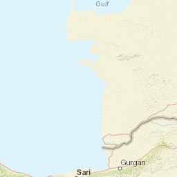
| SARI | 1.352 | 339.56 | Pn | 2025-06-14T02:20:59.1Z | 0 | ||||||||||
| URFA | 1.468 | 77.64 | Pn | 2025-06-14T02:21:00.8Z | 0 | ||||||||||
| DARE | 1.475 | 14.27 | Pn | 2025-06-14T02:21:01.0Z | 0 | ||||||||||
| CMRD | 1.698 | 288.5 | Pn | 2025-06-14T02:21:04.1Z | 0 | ||||||||||
| BNN | 1.944 | 331.92 | Pn | 2025-06-14T02:21:07.7Z | 0 | ||||||||||
| Sta | Dist | EvAz | Phase | Datetime | Tres | Azim | AzRes | Slow | SRes | Def | SNR | Amp | Per | Mag1 | Mag2 |
| Centroid | Nodal Plan 1 | Nodal Plan 2 | Tensor | Moment Inf. | |||||||||||||||||
|---|---|---|---|---|---|---|---|---|---|---|---|---|---|---|---|---|---|---|---|---|---|
| Auth | Datetime | Lat | Lon | Depth | Mw | Strike | Dip | Rake | Strike | Dip | Rake | Mrr | Mtt | Mpp | Mrt | Mrp | Mtp | %DC | %ISO | %CLVD | |
| Auth | Datetime UTC | lat | lon | Depth | Mw | Strike | Dip | Rake | Strike | Dip | Rake | Mrr | Mtt | Mpp | Mrt | Mrp | Mtp | %DC | %ISO | %CLVD | |

