SeismicPortal
 is the European Infrastructure
 for seismological products in :
is the European Infrastructure 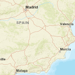


| Datetime (UTC) rmsOT_error |
Lat Smajor |
Lon Sminor |
D. (Km) AzErr |
Ndef mdist |
Nsta Mdist |
Gap | Mag1 (N) Err |
Mag2 (N) Err |
Mag3 (N) Err |
Author Quality |
|---|---|---|---|---|---|---|---|---|---|---|
| 2025-05-14T12:03:42.62Z 0.51+/- 0.9 |
36.6848 8.1 |
-2.8233 3.2 |
11.7 1742.3 |
13 0.09 |
7 1.133 |
226.3 | ml 1.8 (5) 0.4 |
() |
() |
IGN m i ke |
| Sta | Dist | EvAz | Phase | Datetime | Tres | Azim | AzRes | Slow | SRes | Def | SNR | Amp | Per | Mag1 | Mag2 |
|---|---|---|---|---|---|---|---|---|---|---|---|---|---|---|---|
| EXEJI | 0.09 | 6.21 | Pg | 2025-05-14T12:03:44.875Z | -0.3 | ||||||||||
| EXEJI | 0.09 | 6.21 | Sg | 2025-05-14T12:03:47.284Z | 0.2 | ||||||||||
| EXAD | 0.166 | 293.11 | Pg | 2025-05-14T12:03:45.669Z | -0.5 | ||||||||||
| EXAD | 0.166 | 293.11 | Sg | 2025-05-14T12:03:48.56Z | -0.3 | ||||||||||
| EBER | 0.219 | 345.97 | Pg | 2025-05-14T12:03:46.948Z | -0.1 | ||||||||||
| EBER | 0.219 | 345.97 | Sg | 2025-05-14T12:03:50.573Z | 0.2 | 0.0000018519 | ML 1.8 | ||||||||
| ENIJ | 0.571 | 59.76 | Pg | 2025-05-14T12:03:52.297Z | -0.8 | ||||||||||
| ENIJ | 0.571 | 59.76 | Sg | 2025-05-14T12:04:00.922Z | -0.1 | ||||||||||
| ELGU | 0.67 | 286.05 | Pg | 2025-05-14T12:03:54.563Z | -0.3 | ||||||||||
| ELGU | 0.67 | 286.05 | Sg | 2025-05-14T12:04:03.627Z | -0.4 | 0.0000014843 | ML 2.3 | ||||||||
| EQTA | 0.717 | 316.61 | Pg | 2025-05-14T12:03:56.398Z | 0.8 | ||||||||||
| EQTA | 0.717 | 316.61 | Sg | 2025-05-14T12:04:05.352Z | -0.1 | ||||||||||
| EQES | 1.133 | 350.03 | Pg | 2025-05-14T12:04:05.487Z | 2.6 | ||||||||||
| EQES | 1.133 | 350.03 | Sg | 2025-05-14T12:04:17.223Z | -1 | 8.520000000000001e-8 | ML 1.4 | ||||||||
| Sta | Dist | EvAz | Phase | Datetime | Tres | Azim | AzRes | Slow | SRes | Def | SNR | Amp | Per | Mag1 | Mag2 |
| Centroid | Nodal Plan 1 | Nodal Plan 2 | Tensor | Moment Inf. | |||||||||||||||||
|---|---|---|---|---|---|---|---|---|---|---|---|---|---|---|---|---|---|---|---|---|---|
| Auth | Datetime | Lat | Lon | Depth | Mw | Strike | Dip | Rake | Strike | Dip | Rake | Mrr | Mtt | Mpp | Mrt | Mrp | Mtp | %DC | %ISO | %CLVD | |
| Auth | Datetime UTC | lat | lon | Depth | Mw | Strike | Dip | Rake | Strike | Dip | Rake | Mrr | Mtt | Mpp | Mrt | Mrp | Mtp | %DC | %ISO | %CLVD | |

