SeismicPortal
 is the European Infrastructure
 for seismological products in :
is the European Infrastructure 


| Datetime (UTC) rmsOT_error |
Lat Smajor |
Lon Sminor |
D. (Km) AzErr |
Ndef mdist |
Nsta Mdist |
Gap | Mag1 (N) Err |
Mag2 (N) Err |
Mag3 (N) Err |
Author Quality |
|---|---|---|---|---|---|---|---|---|---|---|
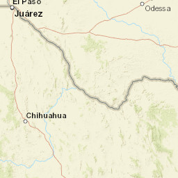
| 2025-05-12T18:16:28.631246Z 0.5+/- 0.85 |
32.001 7.06 |
-102.218 2.74 |
7.5 124.585174560546883.941377639770508 |
16 0.013 |
10 0.303 |
163.8 | ml 2 (7) 0.3 |
() |
() |
TX a i ke |
| Sta | Dist | EvAz | Phase | Datetime | Tres | Azim | AzRes | Slow | SRes | Def | SNR | Amp | Per | Mag1 | Mag2 |
|---|---|---|---|---|---|---|---|---|---|---|---|---|---|---|---|
| MID03 | 0.013 | 28.59 | P | 2025-05-12T18:16:29.69Z | -0.471 | 282.5822359813501 | 0.02488119513063056 | ML 2.4895870036385395 | |||||||
| MID03 | 0.013 | 28.59 | S | 2025-05-12T18:16:30.55Z | -0.739 | ||||||||||
| MB07 | 0.03 | 270.01 | P | 2025-05-12T18:16:30.0Z | -0.452 | 189.1396504795556 | 0.005805781729316132 | ML 1.9181809379743975 | |||||||
| MB07 | 0.03 | 270.01 | S | 2025-05-12T18:16:30.95Z | -0.842 | ||||||||||
| MID01 | 0.056 | 192.42 | P | 2025-05-12T18:16:30.8Z | -0.13 | 142.46110268997955 | 0.003095321800974614 | ML 1.8024398863718318 | |||||||
| MID01 | 0.056 | 192.42 | S | 2025-05-12T18:16:32.43Z | -0.188 | ||||||||||
| MB18 | 0.09 | 25.87 | P | 2025-05-12T18:16:31.55Z | 0.01 | 125.8052285967784 | 0.003551632956520807 | ML 2.0867624839806247 | |||||||
| MB18 | 0.09 | 25.87 | S | 2025-05-12T18:16:33.93Z | 0.258 | ||||||||||
| OG01 | 0.099 | 228.36 | S | 2025-05-12T18:16:34.17Z | 0.228 | ||||||||||
| OG02 | 0.101 | 243.05 | P | 2025-05-12T18:16:31.79Z | 0.059 | 93.65228901293942 | 0.0010882451539917315 | ML 1.6400705900827202 | |||||||
| OG02 | 0.101 | 243.05 | S | 2025-05-12T18:16:34.67Z | 0.668 | ||||||||||
| MID02 | 0.135 | 18.63 | P | 2025-05-12T18:16:32.78Z | 0.428 | 73.88126979127006 | 0.002577529079128647 | ML 2.2041644706732657 | |||||||
| OG04 | 0.14 | 239.29 | P | 2025-05-12T18:16:32.87Z | 0.444 | 51.41958482183632 | 0.000661760267516541 | ML 1.6298580509406286 | |||||||
| MBBB5 | 0.303 | 22.18 | P | 2025-05-12T18:16:35.21Z | -0.131 | 44.27000209924642 | 0.0007118768375905096 | ML 2.1285815420308927 | |||||||
| Sta | Dist | EvAz | Phase | Datetime | Tres | Azim | AzRes | Slow | SRes | Def | SNR | Amp | Per | Mag1 | Mag2 |
| Centroid | Nodal Plan 1 | Nodal Plan 2 | Tensor | Moment Inf. | |||||||||||||||||
|---|---|---|---|---|---|---|---|---|---|---|---|---|---|---|---|---|---|---|---|---|---|
| Auth | Datetime | Lat | Lon | Depth | Mw | Strike | Dip | Rake | Strike | Dip | Rake | Mrr | Mtt | Mpp | Mrt | Mrp | Mtp | %DC | %ISO | %CLVD | |
| Auth | Datetime UTC | lat | lon | Depth | Mw | Strike | Dip | Rake | Strike | Dip | Rake | Mrr | Mtt | Mpp | Mrt | Mrp | Mtp | %DC | %ISO | %CLVD | |

