SeismicPortal
 is the European Infrastructure
 for seismological products in :
is the European Infrastructure 


| Datetime (UTC) rmsOT_error |
Lat Smajor |
Lon Sminor |
D. (Km) AzErr |
Ndef mdist |
Nsta Mdist |
Gap | Mag1 (N) Err |
Mag2 (N) Err |
Mag3 (N) Err |
Author Quality |
|---|---|---|---|---|---|---|---|---|---|---|
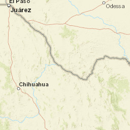
| 2025-05-11T09:56:17.636119Z 0.4+/- 0.71 |
31.669 6.74 |
-104.456 4.19 |
7.9 43.547416687011724.31800317764282 |
11 0.024 |
7 0.989 |
70.7 | ml 2.1 (7) 0.2 |
() |
() |
TX a i ke |
| Sta | Dist | EvAz | Phase | Datetime | Tres | Azim | AzRes | Slow | SRes | Def | SNR | Amp | Per | Mag1 | Mag2 |
|---|---|---|---|---|---|---|---|---|---|---|---|---|---|---|---|
| PB35 | 0.024 | 121.94 | P | 2025-05-11T09:56:19.65Z | 0.216 | 1391.8078263680466 | 0.00661684685924742 | ML 1.991673140678312 | |||||||
| PB35 | 0.024 | 121.94 | S | 2025-05-11T09:56:20.6Z | -0.158 | ||||||||||
| PB36 | 0.028 | 66.22 | P | 2025-05-11T09:56:19.9Z | 0.4 | 1219.4881235461582 | 0.00565399339149943 | ML 1.9386337826718796 | |||||||
| PB36 | 0.028 | 66.22 | S | 2025-05-11T09:56:21.1Z | 0.138 | ||||||||||
| PB28 | 0.038 | 270.01 | P | 2025-05-11T09:56:19.77Z | 0.095 | 3526.6419422533595 | 0.022966579843283645 | ML 2.5949467347115283 | |||||||
| PB29 | 0.097 | 329.46 | P | 2025-05-11T09:56:21.0Z | 0.274 | 487.7911011621067 | 0.0027853134557401515 | ML 2.039867887436691 | |||||||
| PB29 | 0.097 | 329.46 | S | 2025-05-11T09:56:22.94Z | -0.053 | ||||||||||
| SA07 | 0.211 | 21.53 | P | 2025-05-11T09:56:23.207Z | 0.46 | 57.5123827196523 | 0.0008839136978723474 | ML 1.9973545743696066 | |||||||
| SA07 | 0.211 | 21.53 | S | 2025-05-11T09:56:25.667Z | -0.821 | ||||||||||
| PB12 | 0.623 | 136.75 | P | 2025-05-11T09:56:29.855Z | -0.22 | 41.410430313362305 | 0.0003320255788683294 | ML 2.273964974538351 | |||||||
| VHRN | 0.989 | 207.4 | P | 2025-05-11T09:56:36.285Z | -0.33 | 9.991157169792357 | 0.00005929420426965338 | ML 1.9074462674970325 | |||||||
| Sta | Dist | EvAz | Phase | Datetime | Tres | Azim | AzRes | Slow | SRes | Def | SNR | Amp | Per | Mag1 | Mag2 |
| Centroid | Nodal Plan 1 | Nodal Plan 2 | Tensor | Moment Inf. | |||||||||||||||||
|---|---|---|---|---|---|---|---|---|---|---|---|---|---|---|---|---|---|---|---|---|---|
| Auth | Datetime | Lat | Lon | Depth | Mw | Strike | Dip | Rake | Strike | Dip | Rake | Mrr | Mtt | Mpp | Mrt | Mrp | Mtp | %DC | %ISO | %CLVD | |
| Auth | Datetime UTC | lat | lon | Depth | Mw | Strike | Dip | Rake | Strike | Dip | Rake | Mrr | Mtt | Mpp | Mrt | Mrp | Mtp | %DC | %ISO | %CLVD | |

