SeismicPortal
 is the European Infrastructure
 for seismological products in :
is the European Infrastructure 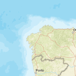


| Datetime (UTC) rmsOT_error |
Lat Smajor |
Lon Sminor |
D. (Km) AzErr |
Ndef mdist |
Nsta Mdist |
Gap | Mag1 (N) Err |
Mag2 (N) Err |
Mag3 (N) Err |
Author Quality |
|---|---|---|---|---|---|---|---|---|---|---|
| 2025-05-10T22:12:41.65Z 0.85+/- 0.55 |
41.6912 4.6 |
-8.4522 2.8 |
3.3 694.9 |
21 0.341 |
10 2.1 |
164.6 | ml 1.8 (7) 0.2 |
() |
() |
IGN m i ke |
| Sta | Dist | EvAz | Phase | Datetime | Tres | Azim | AzRes | Slow | SRes | Def | SNR | Amp | Per | Mag1 | Mag2 |
|---|---|---|---|---|---|---|---|---|---|---|---|---|---|---|---|
| ELOB | 0.341 | 58.83 | Pg | 2025-05-10T22:12:49.71Z | 1.2 | ||||||||||
| ELOB | 0.341 | 58.83 | Sg | 2025-05-10T22:12:53.784Z | 1.2 | 9.701e-7 | ML 1.8 | ||||||||
| EZAM | 0.492 | 338.47 | Pg | 2025-05-10T22:12:51.264Z | 0.6 | ||||||||||
| EZAM | 0.492 | 338.47 | Sg | 2025-05-10T22:12:57.858Z | 0.5 | 4.439e-7 | ML 1.6 | ||||||||
| POLO | 0.587 | 122.48 | Pg | 2025-05-10T22:12:53.243Z | 0.9 | ||||||||||
| POLO | 0.587 | 122.48 | Sg | 2025-05-10T22:13:01.187Z | 0.8 | ||||||||||
| EAGO | 1.143 | 13.52 | Pg | 2025-05-10T22:13:03.29Z | 0.5 | ||||||||||
| EAGO | 1.143 | 13.52 | Sg | 2025-05-10T22:13:16.951Z | -1.2 | 2.511e-7 | ML 1.9 | ||||||||
| MVO | 1.192 | 115.71 | Pg | 2025-05-10T22:13:03.589Z | 0.2 | ||||||||||
| MVO | 1.192 | 115.71 | Sg | 2025-05-10T22:13:19.49Z | -0.7 | ||||||||||
| ECAL | 1.306 | 78.41 | Pg | 2025-05-10T22:13:04.994Z | -0.5 | ||||||||||
| ECAL | 1.306 | 78.41 | Sg | 2025-05-10T22:13:22.368Z | -1 | 1.168e-7 | ML 1.6 | ||||||||
| EMAZ | 1.315 | 342.99 | Pg | 2025-05-10T22:13:06.37Z | 0.4 | ||||||||||
| EMAZ | 1.315 | 342.99 | Sg | 2025-05-10T22:13:22.807Z | -0.9 | 2.387e-7 | ML 2 | ||||||||
| EBUR | 1.643 | 48.36 | Pn | 2025-05-10T22:13:10.3Z | 0.1 | ||||||||||
| EBUR | 1.643 | 48.36 | Sn | 2025-05-10T22:13:30.65Z | -0.6 | 9.91e-8 | ML 1.7 | ||||||||
| EPON | 1.897 | 30.07 | Pn | 2025-05-10T22:13:12.409Z | -1.1 | ||||||||||
| EPON | 1.897 | 30.07 | Sn | 2025-05-10T22:13:37.625Z | 0.3 | 1.649e-7 | ML 2.1 | ||||||||
| PSARD | 2.1 | 173.88 | Pn | 2025-05-10T22:13:16.111Z | -0.2 | ||||||||||
| PSARD | 2.1 | 173.88 | Sn | 2025-05-10T22:13:43.456Z | 1.1 | ||||||||||
| PSARD | 2.1 | 173.88 | Sg | 2025-05-10T22:13:47.42Z | -1.7 | ||||||||||
| Sta | Dist | EvAz | Phase | Datetime | Tres | Azim | AzRes | Slow | SRes | Def | SNR | Amp | Per | Mag1 | Mag2 |
| Centroid | Nodal Plan 1 | Nodal Plan 2 | Tensor | Moment Inf. | |||||||||||||||||
|---|---|---|---|---|---|---|---|---|---|---|---|---|---|---|---|---|---|---|---|---|---|
| Auth | Datetime | Lat | Lon | Depth | Mw | Strike | Dip | Rake | Strike | Dip | Rake | Mrr | Mtt | Mpp | Mrt | Mrp | Mtp | %DC | %ISO | %CLVD | |
| Auth | Datetime UTC | lat | lon | Depth | Mw | Strike | Dip | Rake | Strike | Dip | Rake | Mrr | Mtt | Mpp | Mrt | Mrp | Mtp | %DC | %ISO | %CLVD | |

