SeismicPortal
 is the European Infrastructure
 for seismological products in :
is the European Infrastructure 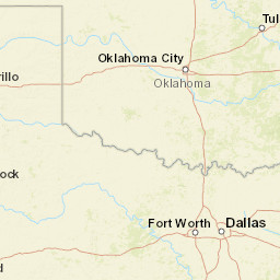


| Datetime (UTC) rmsOT_error |
Lat Smajor |
Lon Sminor |
D. (Km) AzErr |
Ndef mdist |
Nsta Mdist |
Gap | Mag1 (N) Err |
Mag2 (N) Err |
Mag3 (N) Err |
Author Quality |
|---|---|---|---|---|---|---|---|---|---|---|
| 2025-04-29T20:01:57.299999Z 0.26+/- |
34.7088 |
-97.5297 |
6.4 0.6 |
92 0.212 |
46 1.529 |
44.4 | ml 2 (36) 0.24 |
() |
() |
OK m i ke |
| Sta | Dist | EvAz | Phase | Datetime | Tres | Azim | AzRes | Slow | SRes | Def | SNR | Amp | Per | Mag1 | Mag2 |
|---|---|---|---|---|---|---|---|---|---|---|---|---|---|---|---|
| SC09 | 0.212 | 140.4 | P | 2025-04-29T20:02:01.787936Z | -0.15 | ML 1.622219627 | |||||||||
| SC09 | 0.212 | 140.4 | S | 2025-04-29T20:02:05.194812Z | -0.14 | ||||||||||
| SC17 | 0.214 | 344.8 | P | 2025-04-29T20:02:02.275528Z | 0.29 | ML 2.192044109 | |||||||||
| SC17 | 0.214 | 344.8 | S | 2025-04-29T20:02:05.372685Z | -0.05 | ||||||||||
| X34A | 0.272 | 246.81 | P | 2025-04-29T20:02:02.816762Z | -0.27 | ML 1.747427724 | |||||||||
| X34A | 0.272 | 246.81 | S | 2025-04-29T20:02:08.6222Z | 0.69 | ||||||||||
| SC04 | 0.347 | 172.24 | P | 2025-04-29T20:02:04.561882Z | 0.06 | ML 2.65755452 | |||||||||
| SC04 | 0.347 | 172.24 | S | 2025-04-29T20:02:10.260654Z | 0.5 | ||||||||||
| SC03 | 0.35 | 311.37 | P | 2025-04-29T20:02:04.384353Z | -0.17 | ML 2.085080062 | |||||||||
| SC03 | 0.35 | 311.37 | S | 2025-04-29T20:02:10.14299Z | 0.17 | ||||||||||
| COLE | 0.357 | 359.4 | P | 2025-04-29T20:02:04.710164Z | 0.02 | ML 2.013398066 | |||||||||
| COLE | 0.357 | 359.4 | S | 2025-04-29T20:02:10.271283Z | 0.19 | ||||||||||
| BOBW | 0.512 | 45.11 | P | 2025-04-29T20:02:07.517088Z | 0.1 | ML 1.893720981 | |||||||||
| BOBW | 0.512 | 45.11 | S | 2025-04-29T20:02:14.977799Z | 0.17 | ||||||||||
| SC01 | 0.532 | 333.42 | P | 2025-04-29T20:02:07.997819Z | 0.22 | ML 1.916335198 | |||||||||
| SC01 | 0.532 | 333.42 | S | 2025-04-29T20:02:15.444765Z | 0.01 | ||||||||||
| FNO | 0.557 | 10.9 | P | 2025-04-29T20:02:08.514782Z | 0.27 | ML 1.903475192 | |||||||||
| FNO | 0.557 | 10.9 | S | 2025-04-29T20:02:16.99379Z | -0.12 | ||||||||||
| TUTT | 0.56 | 340.67 | P | 2025-04-29T20:02:08.588227Z | 0.3 | ML 2.012565515 | |||||||||
| TUTT | 0.56 | 340.67 | S | 2025-04-29T20:02:16.172824Z | -0.15 | ||||||||||
| WADE | 0.563 | 187.57 | P | 2025-04-29T20:02:08.188082Z | -0.13 | ML 2.124512681 | |||||||||
| WADE | 0.563 | 187.57 | S | 2025-04-29T20:02:16.791299Z | 0.43 | ||||||||||
| TG09 | 0.591 | 338.18 | P | 2025-04-29T20:02:08.600516Z | -0.25 | ML 2.249745486 | |||||||||
| TG09 | 0.591 | 338.18 | S | 2025-04-29T20:02:17.27256Z | -0.01 | ||||||||||
| TG08 | 0.602 | 339.04 | P | 2025-04-29T20:02:09.4786Z | 0.01 | ML 2.129360023 | |||||||||
| TG08 | 0.602 | 339.04 | S | 2025-04-29T20:02:17.472132Z | -0.13 | ||||||||||
| TG02 | 0.607 | 338.26 | P | 2025-04-29T20:02:08.882918Z | -0.24 | ML 2.283080309 | |||||||||
| TG02 | 0.607 | 338.26 | S | 2025-04-29T20:02:17.678848Z | -0.07 | ||||||||||
| TG07 | 0.607 | 339.36 | P | 2025-04-29T20:02:09.214626Z | 0.09 | ML 2.148766321 | |||||||||
| TG07 | 0.607 | 339.36 | S | 2025-04-29T20:02:17.638897Z | -0.12 | ||||||||||
| MOOR | 0.641 | 350.5 | P | 2025-04-29T20:02:10.149981Z | 0.44 | ML 2.232520694 | |||||||||
| MOOR | 0.641 | 350.5 | S | 2025-04-29T20:02:18.588018Z | -0.18 | ||||||||||
| SC14 | 0.643 | 246.71 | P | 2025-04-29T20:02:09.466824Z | -0.27 | ML 1.304278214 | |||||||||
| SC14 | 0.643 | 246.71 | S | 2025-04-29T20:02:18.524291Z | -0.31 | ||||||||||
| POCA | 0.677 | 318.75 | P | 2025-04-29T20:02:10.691399Z | 0.32 | ML 1.486847772 | |||||||||
| POCA | 0.677 | 318.75 | S | 2025-04-29T20:02:20.37935Z | 0.12 | ||||||||||
| W35A | 0.698 | 50.37 | P | 2025-04-29T20:02:10.490875Z | -0.21 | ML 2.003392238 | |||||||||
| W35A | 0.698 | 50.37 | S | 2025-04-29T20:02:20.498138Z | 0.01 | ||||||||||
| UCTY | 0.75 | 335.11 | P | 2025-04-29T20:02:11.829724Z | 0.17 | ML 2.417582177 | |||||||||
| UCTY | 0.75 | 335.11 | S | 2025-04-29T20:02:22.43465Z | -0.1 | ||||||||||
| SHWN | 0.757 | 33.17 | P | 2025-04-29T20:02:11.958779Z | 0.2 | ML 1.283895912 | |||||||||
| SHWN | 0.757 | 33.17 | S | 2025-04-29T20:02:22.420293Z | 0.1 | ||||||||||
| LOOK | 0.771 | 157.87 | P | 2025-04-29T20:02:12.9234Z | 0 | ML 2.121433171 | |||||||||
| LOOK | 0.771 | 157.87 | S | 2025-04-29T20:02:23.654549Z | 0.91 | ||||||||||
| ERNS | 0.823 | 330.29 | P | 2025-04-29T20:02:12.55291Z | -0.42 | ML 2.033437246 | |||||||||
| ERNS | 0.823 | 330.29 | S | 2025-04-29T20:02:24.294581Z | -0.11 | ||||||||||
| TISH | 0.857 | 107.95 | P | 2025-04-29T20:02:13.125225Z | -0.37 | ML 2.159234673 | |||||||||
| TISH | 0.857 | 107.95 | S | 2025-04-29T20:02:25.18313Z | -0.31 | ||||||||||
| YUKO | 0.871 | 341.95 | P | 2025-04-29T20:02:13.789586Z | -0.02 | ML 2.177130062 | |||||||||
| YUKO | 0.871 | 341.95 | S | 2025-04-29T20:02:25.558787Z | -0.3 | ||||||||||
| CHOK | 0.933 | 24.18 | P | 2025-04-29T20:02:14.674051Z | -0.22 | ML 2.085369198 | |||||||||
| CHOK | 0.933 | 24.18 | S | 2025-04-29T20:02:27.792237Z | 0.06 | ||||||||||
| SC10 | 0.937 | 319.73 | P | 2025-04-29T20:02:15.404557Z | 0.39 | ML 1.52878936 | |||||||||
| SC10 | 0.937 | 319.73 | S | 2025-04-29T20:02:27.848249Z | -0.09 | ||||||||||
| BLUF | 0.948 | 356.09 | P | 2025-04-29T20:02:15.298821Z | 0.16 | ML 1.63960308 | |||||||||
| BLUF | 0.948 | 356.09 | S | 2025-04-29T20:02:27.962758Z | -0.2 | ||||||||||
| ADOK | 0.95 | 7.82 | P | 2025-04-29T20:02:15.150758Z | -0.05 | ||||||||||
| ADOK | 0.95 | 7.82 | S | 2025-04-29T20:02:27.924815Z | -0.34 | ||||||||||
| SMNL | 0.984 | 53.33 | P | 2025-04-29T20:02:15.778264Z | -0.01 | ML 2.298235662 | |||||||||
| SMNL | 0.984 | 53.33 | S | 2025-04-29T20:02:29.345983Z | 0.07 | ||||||||||
| SC20 | 1.019 | 313.07 | P | 2025-04-29T20:02:17.68117Z | 0.61 | ML 1.915890509 | |||||||||
| SC20 | 1.019 | 313.07 | S | 2025-04-29T20:02:30.967609Z | 0.51 | ||||||||||
| WILZ | 1.05 | 37.96 | P | 2025-04-29T20:02:16.825303Z | -0.12 | ML 1.651361786 | |||||||||
| WILZ | 1.05 | 37.96 | S | 2025-04-29T20:02:31.772494Z | 0.48 | ||||||||||
| ARC2 | 1.053 | 11.48 | P | 2025-04-29T20:02:16.719204Z | -0.29 | ML 1.618122204 | |||||||||
| ARC2 | 1.053 | 11.48 | S | 2025-04-29T20:02:31.107622Z | -0.29 | ||||||||||
| CHAN | 1.122 | 32.71 | P | 2025-04-29T20:02:18.45794Z | 0.24 | ML 1.978766036 | |||||||||
| CHAN | 1.122 | 32.71 | S | 2025-04-29T20:02:33.754365Z | 0.26 | ||||||||||
| WTFS | 1.219 | 219.75 | P | 2025-04-29T20:02:19.334876Z | -0.6 | ML 1.477338492 | |||||||||
| WTFS | 1.219 | 219.75 | S | 2025-04-29T20:02:35.750265Z | -0.7 | ||||||||||
| PERK | 1.258 | 14.95 | P | 2025-04-29T20:02:20.264468Z | -0.37 | ML 1.583264485 | |||||||||
| PERK | 1.258 | 14.95 | S | 2025-04-29T20:02:37.830911Z | 0.16 | ||||||||||
| DOVR | 1.298 | 343.35 | P | 2025-04-29T20:02:21.54883Z | 0.19 | ML 1.697124707 | |||||||||
| DOVR | 1.298 | 343.35 | S | 2025-04-29T20:02:39.119227Z | 0.19 | ||||||||||
| DUST | 1.298 | 63.56 | P | 2025-04-29T20:02:21.180598Z | -0.17 | ||||||||||
| DUST | 1.298 | 63.56 | S | 2025-04-29T20:02:38.956581Z | 0.05 | ||||||||||
| CRES | 1.325 | 359.85 | P | 2025-04-29T20:02:22.38732Z | 0.2 | ML 1.857550995 | |||||||||
| CRES | 1.325 | 359.85 | S | 2025-04-29T20:02:39.712267Z | -0.04 | ||||||||||
| DEOK | 1.412 | 36.42 | P | 2025-04-29T20:02:22.896395Z | -0.46 | ML 1.874905473 | |||||||||
| DEOK | 1.412 | 36.42 | S | 2025-04-29T20:02:42.443751Z | 0.06 | ||||||||||
| OK052 | 1.413 | 24.65 | P | 2025-04-29T20:02:23.511913Z | 0.14 | ML 2.188935778 | |||||||||
| OK052 | 1.413 | 24.65 | S | 2025-04-29T20:02:42.420466Z | 0.01 | ||||||||||
| RNSP | 1.424 | 329.32 | P | 2025-04-29T20:02:23.239395Z | -0.41 | ML 2.140984199 | |||||||||
| RNSP | 1.424 | 329.32 | S | 2025-04-29T20:02:42.829338Z | -0.05 | ||||||||||
| MRSH | 1.426 | 354.62 | P | 2025-04-29T20:02:22.870726Z | -0.76 | ML 2.277310299 | |||||||||
| MRSH | 1.426 | 354.62 | S | 2025-04-29T20:02:42.545842Z | -0.31 | ||||||||||
| HTCH | 1.461 | 333.53 | P | 2025-04-29T20:02:23.98684Z | -0.27 | ||||||||||
| HTCH | 1.461 | 333.53 | S | 2025-04-29T20:02:43.449022Z | -0.49 | ||||||||||
| SC12 | 1.517 | 278.58 | P | 2025-04-29T20:02:24.80674Z | -1.21 | ||||||||||
| SC12 | 1.517 | 278.58 | S | 2025-04-29T20:02:44.969515Z | -0.75 | ||||||||||
| SC19 | 1.529 | 350.46 | P | 2025-04-29T20:02:25.189553Z | -0.28 | ||||||||||
| SC19 | 1.529 | 350.46 | S | 2025-04-29T20:02:45.958345Z | -0.07 | ||||||||||
| Sta | Dist | EvAz | Phase | Datetime | Tres | Azim | AzRes | Slow | SRes | Def | SNR | Amp | Per | Mag1 | Mag2 |
| Centroid | Nodal Plan 1 | Nodal Plan 2 | Tensor | Moment Inf. | |||||||||||||||||
|---|---|---|---|---|---|---|---|---|---|---|---|---|---|---|---|---|---|---|---|---|---|
| Auth | Datetime | Lat | Lon | Depth | Mw | Strike | Dip | Rake | Strike | Dip | Rake | Mrr | Mtt | Mpp | Mrt | Mrp | Mtp | %DC | %ISO | %CLVD | |
| Auth | Datetime UTC | lat | lon | Depth | Mw | Strike | Dip | Rake | Strike | Dip | Rake | Mrr | Mtt | Mpp | Mrt | Mrp | Mtp | %DC | %ISO | %CLVD | |
