SeismicPortal
 is the European Infrastructure
 for seismological products in :
is the European Infrastructure 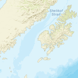


| Datetime (UTC) rmsOT_error |
Lat Smajor |
Lon Sminor |
D. (Km) AzErr |
Ndef mdist |
Nsta Mdist |
Gap | Mag1 (N) Err |
Mag2 (N) Err |
Mag3 (N) Err |
Author Quality |
|---|---|---|---|---|---|---|---|---|---|---|
| 2025-04-27T07:41:42.416Z 0.51+/- 1.04 |
57.4101 5.69 |
-154.0388 3.04 |
35 1101.999 |
31 0.856 |
28 5.811 |
121.5 | ml 2.5 (32) 0.06 |
() |
() |
NEIC m i ke |
| 2025-04-27T07:41:43.9Z 0.4+/- |
57.4013 0.6 |
-154.0612 0.4 |
36.3 239.071.3 |
0 |
0 |
ml 2.6 () |
() |
() |
AK m i ke |
| Sta | Dist | EvAz | Phase | Datetime | Tres | Azim | AzRes | Slow | SRes | Def | SNR | Amp | Per | Mag1 | Mag2 |
|---|---|---|---|---|---|---|---|---|---|---|---|---|---|---|---|
| SII | 0.856 | 185.38 | Pn | 2025-04-27T07:41:57.46Z | -0.52 | 4.3252e-7 | 0.54 | ML 2.96 | |||||||
| SII | 0.856 | 185.38 | Sn | 2025-04-27T07:42:10.7Z | 1.42 | 3.03225e-7 | 0.42 | ML 2.81 | |||||||
| KDAK | 0.867 | 63.88 | Pn | 2025-04-27T07:41:58.51Z | 0.41 | 7.86845e-8 | 0.325 | ML 2.23 | |||||||
| KDAK | 0.867 | 63.88 | Sn | 2025-04-27T07:42:10.75Z | 1.24 | 8.05529e-8 | 0.425 | ML 2.24 | |||||||
| KAB2 | 0.879 | 325.61 | Pn | 2025-04-27T07:41:57.86Z | -0.5 | ||||||||||
| MGLS | 0.942 | 320.79 | Pn | 2025-04-27T07:41:58.74Z | -0.43 | ||||||||||
| KAVE | 0.949 | 326.72 | Pn | 2025-04-27T07:41:58.96Z | -0.33 | ||||||||||
| KAKN | 1.042 | 328.79 | Pn | 2025-04-27T07:42:00.26Z | -0.37 | ||||||||||
| ACH | 1.057 | 319.84 | Pn | 2025-04-27T07:42:00.5Z | -0.32 | 7.59516e-8 | 0.92 | ML 2.34 | |||||||
| ACH | 1.057 | 319.84 | Sn | 2025-04-27T07:42:12.78Z | -1.58 | ||||||||||
| KBM | 1.066 | 324.77 | Pn | 2025-04-27T07:42:01.26Z | 0.35 | ||||||||||
| KABU | 1.088 | 322.85 | Pn | 2025-04-27T07:42:01.54Z | 0.28 | ||||||||||
| KVT | 1.181 | 325.92 | Pn | 2025-04-27T07:42:02.68Z | 0.21 | ||||||||||
| PLK2 | 1.28 | 287.04 | Pn | 2025-04-27T07:42:03.74Z | -0.07 | ||||||||||
| KEL | 1.374 | 319.33 | Pn | 2025-04-27T07:42:05.22Z | 0.05 | ||||||||||
| PLK1 | 1.436 | 286.9 | Pn | 2025-04-27T07:42:06.42Z | 0.5 | ||||||||||
| PLBL | 1.525 | 282.11 | Pn | 2025-04-27T07:42:07.52Z | 0.33 | 1.07279e-7 | 0.56 | ML 2.75 | |||||||
| P17K | 2.19 | 325.72 | Pn | 2025-04-27T07:42:16.55Z | 0.25 | 5.1667e-8 | 1.18 | ML 2.74 | |||||||
| ANNW | 2.315 | 260.68 | Pn | 2025-04-27T07:42:18.29Z | 0.2 | 2.92771e-8 | 1.18 | ML 2.55 | |||||||
| ANPB | 2.391 | 257.04 | Pn | 2025-04-27T07:42:18.82Z | -0.3 | 1.93384e-8 | 0.72 | ML 2.4 | |||||||
| O18K | 2.523 | 346.49 | Pn | 2025-04-27T07:42:21.14Z | 0.22 | 1.56201e-8 | 1.14 | ML 2.36 | |||||||
| BRLK | 2.86 | 33.62 | Pn | 2025-04-27T07:42:25.54Z | 0 | 8.02785e-9 | 0.96 | ML 2.2 | |||||||
| N18K | 3.412 | 344.53 | Pn | 2025-04-27T07:42:33.33Z | 0.19 | 5.527e-9 | 0.98 | ML 2.24 | |||||||
| SLK | 3.678 | 30.86 | Pn | 2025-04-27T07:42:36.71Z | -0.13 | 5.9924e-9 | 1.18 | ML 2.36 | |||||||
| N15K | 4.186 | 313.84 | Pn | 2025-04-27T07:42:44.54Z | 0.77 | 4.7845e-9 | 1.18 | ML 2.43 | |||||||
| M16K | 4.411 | 327.16 | Pn | 2025-04-27T07:42:47.57Z | 0.71 | 2.9245e-9 | 1.02 | ML 2.29 | |||||||
| PWL | 4.531 | 37.96 | Pn | 2025-04-27T07:42:47.96Z | -0.56 | 6.87385e-9 | 1.16 | ML 2.7 | |||||||
| HIN | 4.915 | 49.37 | Pn | 2025-04-27T07:42:52.89Z | -0.91 | 5.78107e-8 | 1.2 | ML 3.75 | |||||||
| FID | 5.072 | 45.95 | Pn | 2025-04-27T07:42:55.19Z | -0.75 | 1.30717e-8 | 1.04 | ML 3.15 | |||||||
| SCM | 5.582 | 34.69 | Pn | 2025-04-27T07:43:02.81Z | -0.21 | ||||||||||
| KLU | 5.811 | 41.91 | Pn | 2025-04-27T07:43:05.77Z | -0.4 | ||||||||||
| Sta | Dist | EvAz | Phase | Datetime | Tres | Azim | AzRes | Slow | SRes | Def | SNR | Amp | Per | Mag1 | Mag2 |
| Sta | Dist | EvAz | Phase | Datetime | Tres | Azim | AzRes | Slow | SRes | Def | SNR | Amp | Per | Mag1 | Mag2 |
|---|---|---|---|---|---|---|---|---|---|---|---|---|---|---|---|
| Sta | Dist | EvAz | Phase | Datetime | Tres | Azim | AzRes | Slow | SRes | Def | SNR | Amp | Per | Mag1 | Mag2 |
| Centroid | Nodal Plan 1 | Nodal Plan 2 | Tensor | Moment Inf. | |||||||||||||||||
|---|---|---|---|---|---|---|---|---|---|---|---|---|---|---|---|---|---|---|---|---|---|
| Auth | Datetime | Lat | Lon | Depth | Mw | Strike | Dip | Rake | Strike | Dip | Rake | Mrr | Mtt | Mpp | Mrt | Mrp | Mtp | %DC | %ISO | %CLVD | |
| Auth | Datetime UTC | lat | lon | Depth | Mw | Strike | Dip | Rake | Strike | Dip | Rake | Mrr | Mtt | Mpp | Mrt | Mrp | Mtp | %DC | %ISO | %CLVD | |

