SeismicPortal
 is the European Infrastructure
 for seismological products in :
is the European Infrastructure 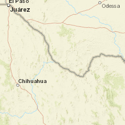


| Datetime (UTC) rmsOT_error |
Lat Smajor |
Lon Sminor |
D. (Km) AzErr |
Ndef mdist |
Nsta Mdist |
Gap | Mag1 (N) Err |
Mag2 (N) Err |
Mag3 (N) Err |
Author Quality |
|---|---|---|---|---|---|---|---|---|---|---|
| 2025-04-23T20:40:24.38255Z 0.3+/- 1.06 |
31.375 9.2 |
-103.465 3.47 |
10.1 25.1825656890869145.64359951019287 |
11 0.051 |
7 0.344 |
123.6 | ml 2 (7) 0.3 |
() |
() |
TX a i ke |
| Sta | Dist | EvAz | Phase | Datetime | Tres | Azim | AzRes | Slow | SRes | Def | SNR | Amp | Per | Mag1 | Mag2 |
|---|---|---|---|---|---|---|---|---|---|---|---|---|---|---|---|
| PCOS | 0.051 | 311.39 | P | 2025-04-23T20:40:26.545Z | -0.463 | 26.30538749195595 | 0.0010551539074566422 | ML 1.4873486970966714 | |||||||
| DG02 | 0.072 | 292 | P | 2025-04-23T20:40:26.912Z | -0.452 | 9.563101773849118 | 0.0018320191708307268 | ML 1.8207984671741673 | |||||||
| DG02 | 0.072 | 292 | S | 2025-04-23T20:40:29.322Z | -0.233 | ||||||||||
| DG07 | 0.095 | 325.31 | P | 2025-04-23T20:40:28.23Z | 0.473 | 28.90933401240944 | 0.0017461713221500917 | ML 1.9114730329272542 | |||||||
| DG07 | 0.095 | 325.31 | S | 2025-04-23T20:40:30.5Z | 0.265 | ||||||||||
| PB30 | 0.154 | 127.89 | P | 2025-04-23T20:40:28.5495Z | -0.256 | 19.45029668655254 | 0.0019138404040038182 | ML 2.186947210732386 | |||||||
| PB30 | 0.154 | 127.89 | S | 2025-04-23T20:40:32.2195Z | 0.17 | ||||||||||
| DG01 | 0.166 | 88.92 | P | 2025-04-23T20:40:28.838Z | -0.172 | 108.6879021323014 | 0.0022140284779068164 | ML 2.2877737605642596 | |||||||
| DG01 | 0.166 | 88.92 | S | 2025-04-23T20:40:32.468Z | 0.064 | ||||||||||
| PB10 | 0.264 | 250 | P | 2025-04-23T20:40:31.6Z | 0.358 | 24.60606349598832 | 0.0010746460291100883 | ML 2.2345009635186788 | |||||||
| PECS | 0.344 | 269.27 | P | 2025-04-23T20:40:32.33Z | 0.245 | 16.00011682559424 | 0.00019304004317788548 | ML 1.6523732844659658 | |||||||
| Sta | Dist | EvAz | Phase | Datetime | Tres | Azim | AzRes | Slow | SRes | Def | SNR | Amp | Per | Mag1 | Mag2 |
| Centroid | Nodal Plan 1 | Nodal Plan 2 | Tensor | Moment Inf. | |||||||||||||||||
|---|---|---|---|---|---|---|---|---|---|---|---|---|---|---|---|---|---|---|---|---|---|
| Auth | Datetime | Lat | Lon | Depth | Mw | Strike | Dip | Rake | Strike | Dip | Rake | Mrr | Mtt | Mpp | Mrt | Mrp | Mtp | %DC | %ISO | %CLVD | |
| Auth | Datetime UTC | lat | lon | Depth | Mw | Strike | Dip | Rake | Strike | Dip | Rake | Mrr | Mtt | Mpp | Mrt | Mrp | Mtp | %DC | %ISO | %CLVD | |

