SeismicPortal
 is the European Infrastructure
 for seismological products in :
is the European Infrastructure 


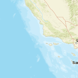


| Datetime (UTC) rmsOT_error |
Lat Smajor |
Lon Sminor |
D. (Km) AzErr |
Ndef mdist |
Nsta Mdist |
Gap | Mag1 (N) Err |
Mag2 (N) Err |
Mag3 (N) Err |
Author Quality |
|---|---|---|---|---|---|---|---|---|---|---|
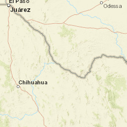
| 2025-04-19T06:14:36.916168Z 0.3+/- |
31.651 0.83 |
-104.305 0.42 |
6.5 18.934675343924370.6906526886294903 |
34 0.04 |
17 1.04 |
68.5 | ml 2 (13) 0.1 |
() |
() |
TX m i ke |
| Sta | Dist | EvAz | Phase | Datetime | Tres | Azim | AzRes | Slow | SRes | Def | SNR | Amp | Per | Mag1 | Mag2 |
|---|---|---|---|---|---|---|---|---|---|---|---|---|---|---|---|
| SA02 | 0.04 | 58.94 | P | 2025-04-19T06:14:38.784442Z | 0.039 | 4376.501724859557 | 0.019338011913834496 | ML 2.3974699794904515 | |||||||
| SA02 | 0.04 | 58.94 | S | 2025-04-19T06:14:39.794044Z | -0.324 | ||||||||||
| PB36 | 0.107 | 285.84 | P | 2025-04-19T06:14:39.873228Z | 0.065 | 273.4501953302062 | 0.001634942036578132 | ML 1.8171776111186615 | |||||||
| PB36 | 0.107 | 285.84 | S | 2025-04-19T06:14:41.635082Z | -0.342 | ||||||||||
| PB35 | 0.108 | 272.77 | P | 2025-04-19T06:14:39.81384Z | -0.02 | 331.4632306081261 | 0.002249028960850025 | ML 1.9645687825824267 | |||||||
| PB35 | 0.108 | 272.77 | S | 2025-04-19T06:14:41.635082Z | -0.387 | ||||||||||
| SA04 | 0.113 | 22.16 | P | 2025-04-19T06:14:39.939215Z | 0.049 | 451.7934703289969 | 0.0027055201777422 | ML 2.0756859836711388 | |||||||
| SA04 | 0.113 | 22.16 | S | 2025-04-19T06:14:41.813246Z | -0.308 | ||||||||||
| PB38 | 0.13 | 307.06 | P | 2025-04-19T06:14:40.236157Z | 0.003 | 138.36829811039343 | 0.0007790943973039295 | ML 1.636196960671886 | |||||||
| PB38 | 0.13 | 307.06 | S | 2025-04-19T06:14:42.367537Z | -0.353 | ||||||||||
| PB26 | 0.169 | 115.37 | P | 2025-04-19T06:14:40.876231Z | -0.058 | 95.90866777222683 | 0.0010511942340442864 | ML 1.9261304881203343 | |||||||
| PB26 | 0.169 | 115.37 | S | 2025-04-19T06:14:43.528909Z | -0.419 | ||||||||||
| SA06 | 0.169 | 51.3 | P | 2025-04-19T06:14:40.93562Z | 0.008 | 24.389518359345793 | 0.0016952943553777545 | ML 2.1330048997760076 | |||||||
| SA06 | 0.169 | 51.3 | S | 2025-04-19T06:14:43.581699Z | -0.354 | ||||||||||
| PB23 | 0.198 | 86.19 | P | 2025-04-19T06:14:41.456917Z | -0.005 | 175.95168768505 | 0.0009801092647187312 | ML 1.9917984879129065 | |||||||
| PB23 | 0.198 | 86.19 | S | 2025-04-19T06:14:44.551708Z | -0.319 | ||||||||||
| PB29 | 0.205 | 299.77 | P | 2025-04-19T06:14:41.707668Z | 0.062 | 54.74954815582485 | 0.0006024483377312373 | ML 1.8016999767578548 | |||||||
| PB29 | 0.205 | 299.77 | S | 2025-04-19T06:14:44.663886Z | -0.529 | ||||||||||
| PB20 | 0.209 | 96.22 | P | 2025-04-19T06:14:41.69447Z | 0.036 | 12.356940556624943 | 0.0009252369211908804 | ML 1.9982835897031221 | |||||||
| PB20 | 0.209 | 96.22 | S | 2025-04-19T06:14:44.888242Z | -0.328 | ||||||||||
| PB25 | 0.212 | 108.6 | P | 2025-04-19T06:14:41.839642Z | 0.122 | 33.964842894293085 | 0.001144750646590084 | ML 2.099510811142723 | |||||||
| PB25 | 0.212 | 108.6 | S | 2025-04-19T06:14:44.927834Z | -0.391 | ||||||||||
| SA07 | 0.22 | 346.59 | P | 2025-04-19T06:14:41.734063Z | -0.166 | 68.8992166189447 | 0.0005688282635678217 | ML 1.8216986049662727 | |||||||
| SA07 | 0.22 | 346.59 | S | 2025-04-19T06:14:45.211578Z | -0.427 | ||||||||||
| PB33 | 0.243 | 118.3 | P | 2025-04-19T06:14:42.275156Z | -0.039 | 88.52979273110417 | 0.0008120350595252867 | ML 2.0398517545569264 | |||||||
| PB33 | 0.243 | 118.3 | S | 2025-04-19T06:14:45.818659Z | -0.545 | ||||||||||
| SA09 | 0.348 | 358.04 | P | 2025-04-19T06:14:44.23812Z | -0.281 | 25.07431256902113 | 0.0002674902009734887 | ML 1.790450032170512 | |||||||
| SA09 | 0.348 | 358.04 | S | 2025-04-19T06:14:48.939844Z | -0.907 | ||||||||||
| PECS | 0.467 | 126.71 | P | 2025-04-19T06:14:46.498325Z | -0.005 | 22.851467102089686 | 0.00021780324442695543 | ML 1.8959484980539258 | |||||||
| PECS | 0.467 | 126.71 | S | 2025-04-19T06:14:52.793486Z | -0.901 | ||||||||||
| PB12 | 0.528 | 145.72 | P | 2025-04-19T06:14:47.596984Z | -0.088 | 16.27976597660122 | 0.0004978839673007569 | ML 2.3380297829349233 | |||||||
| PB12 | 0.528 | 145.72 | S | 2025-04-19T06:14:54.91904Z | -0.843 | ||||||||||
| VHRN | 1.04 | 214.25 | P | 2025-04-19T06:14:56.654872Z | -0.626 | 14.54126175040146 | 0.00010003679861161815 | ML 2.1421240181359806 | |||||||
| VHRN | 1.04 | 214.25 | S | 2025-04-19T06:15:10.415287Z | -2.141 | ||||||||||
| Sta | Dist | EvAz | Phase | Datetime | Tres | Azim | AzRes | Slow | SRes | Def | SNR | Amp | Per | Mag1 | Mag2 |
| Centroid | Nodal Plan 1 | Nodal Plan 2 | Tensor | Moment Inf. | |||||||||||||||||
|---|---|---|---|---|---|---|---|---|---|---|---|---|---|---|---|---|---|---|---|---|---|
| Auth | Datetime | Lat | Lon | Depth | Mw | Strike | Dip | Rake | Strike | Dip | Rake | Mrr | Mtt | Mpp | Mrt | Mrp | Mtp | %DC | %ISO | %CLVD | |
| Auth | Datetime UTC | lat | lon | Depth | Mw | Strike | Dip | Rake | Strike | Dip | Rake | Mrr | Mtt | Mpp | Mrt | Mrp | Mtp | %DC | %ISO | %CLVD | |

