SeismicPortal
 is the European Infrastructure
 for seismological products in :
is the European Infrastructure 


| Datetime (UTC) rmsOT_error |
Lat Smajor |
Lon Sminor |
D. (Km) AzErr |
Ndef mdist |
Nsta Mdist |
Gap | Mag1 (N) Err |
Mag2 (N) Err |
Mag3 (N) Err |
Author Quality |
|---|---|---|---|---|---|---|---|---|---|---|
| 2025-04-17T17:53:35.276727Z 2.76+/- |
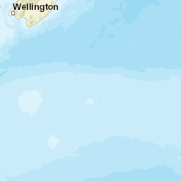
-41.1787 66.8 |
172.7809 47.43 |
62.6 119.261489806481850.3717078594228 |
12 0.401 |
12 2.893 |
99.5 | m 3.8 (1) |
() |
() |
GNS a i ke |
| Sta | Dist | EvAz | Phase | Datetime | Tres | Azim | AzRes | Slow | SRes | Def | SNR | Amp | Per | Mag1 | Mag2 |
|---|---|---|---|---|---|---|---|---|---|---|---|---|---|---|---|
| QRZ | 0.401 | 331.57 | P | 2025-04-17T17:53:46.48Z | -0.545 | ||||||||||
| NNZ | 0.454 | 95.04 | P | 2025-04-17T17:53:47.8Z | 0.386 | ||||||||||
| THZ | 0.591 | 170.96 | P | 2025-04-17T17:53:55.42Z | 6.281 | ||||||||||
| DSZ | 0.926 | 232.03 | P | 2025-04-17T17:53:59.1313Z | 5.692 | ||||||||||
| KHZ | 1.36 | 155.62 | P | 2025-04-17T17:53:58.33Z | -0.803 | ||||||||||
| LTZ | 1.646 | 193.18 | P | 2025-04-17T17:54:05.35Z | 2.251 | ||||||||||
| GVZ | 1.796 | 174.04 | P | 2025-04-17T17:54:04.26Z | -0.879 | ||||||||||
| INZ | 1.837 | 212.41 | P | 2025-04-17T17:54:06.98313Z | 2.054 | ML 3.7785406200852685 | |||||||||
| OXZ | 2.215 | 194.17 | P | 2025-04-17T17:54:10.19Z | -0.151 | ||||||||||
| IFMZ | 2.244 | 214.2 | P | 2025-04-17T17:54:11.58Z | |||||||||||
| DBHZ | 2.372 | 206.81 | P | 2025-04-17T17:54:11.66Z | |||||||||||
| SMRZ | 2.53 | 216.51 | P | 2025-04-17T17:54:12.97Z | |||||||||||
| TRVZ | 2.83 | 49.35 | P | 2025-04-17T17:54:21.95Z | 2.948 | ||||||||||
| RPZ | 2.837 | 206.18 | P | 2025-04-17T17:54:17.4Z | -1.588 | ||||||||||
| ANWZ | 2.893 | 76.85 | P | 2025-04-17T17:54:24.18313Z | 4.35 | ||||||||||
| Sta | Dist | EvAz | Phase | Datetime | Tres | Azim | AzRes | Slow | SRes | Def | SNR | Amp | Per | Mag1 | Mag2 |
| Centroid | Nodal Plan 1 | Nodal Plan 2 | Tensor | Moment Inf. | |||||||||||||||||
|---|---|---|---|---|---|---|---|---|---|---|---|---|---|---|---|---|---|---|---|---|---|
| Auth | Datetime | Lat | Lon | Depth | Mw | Strike | Dip | Rake | Strike | Dip | Rake | Mrr | Mtt | Mpp | Mrt | Mrp | Mtp | %DC | %ISO | %CLVD | |
| Auth | Datetime UTC | lat | lon | Depth | Mw | Strike | Dip | Rake | Strike | Dip | Rake | Mrr | Mtt | Mpp | Mrt | Mrp | Mtp | %DC | %ISO | %CLVD | |

