SeismicPortal
 is the European Infrastructure
 for seismological products in :
is the European Infrastructure 

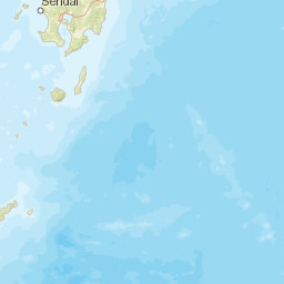


| Datetime (UTC) rmsOT_error |
Lat Smajor |
Lon Sminor |
D. (Km) AzErr |
Ndef mdist |
Nsta Mdist |
Gap | Mag1 (N) Err |
Mag2 (N) Err |
Mag3 (N) Err |
Author Quality |
|---|---|---|---|---|---|---|---|---|---|---|
| 2025-03-26T18:39:53.3Z +/- |
27.84 |
139.88 |
480 |
22 8.797 |
22 75.963 |
159.2 | mb 4.1 () |
() |
() |
GSRAS m i ke |
| Sta | Dist | EvAz | Phase | Datetime | Tres | Azim | AzRes | Slow | SRes | Def | SNR | Amp | Per | Mag1 | Mag2 |
|---|---|---|---|---|---|---|---|---|---|---|---|---|---|---|---|
| MAJO | 8.797 | 351.14 | P | 2025-03-26T18:41:57.9Z | 0 | ||||||||||
| KLR | 22.254 | 345.84 | P | 2025-03-26T18:44:14.5Z | 0 | ||||||||||
| ZEA | 27.488 | 343.67 | P | 2025-03-26T18:45:00.5Z | 0 | ||||||||||
| TUP | 30.28 | 336.77 | P | 2025-03-26T18:45:24.4Z | 0 | ||||||||||
| ULN | 32.373 | 317.07 | P | 2025-03-26T18:45:42.1Z | 0 | ||||||||||
| YAK | 34.838 | 351.61 | P | 2025-03-26T18:46:02.7Z | 0 | ||||||||||
| SEY | 36.019 | 9.67 | P | 2025-03-26T18:46:14.2Z | 0 | ||||||||||
| CHTO | 38.523 | 265.58 | P | 2025-03-26T18:46:34.3Z | 0 | ||||||||||
| CMAR | 38.654 | 265.05 | P | 2025-03-26T18:46:35.0Z | 0 | ||||||||||
| CM31 | 38.654 | 265.05 | P | 2025-03-26T18:46:35.1Z | 0 | ||||||||||
| BILL | 43.242 | 14.17 | P | 2025-03-26T18:47:11.9Z | 0 | ||||||||||
| TIXI | 44.228 | 355.03 | P | 2025-03-26T18:47:18.8Z | 0 | ||||||||||
| DGZ | 45.258 | 313.63 | P | 2025-03-26T18:47:27.8Z | 0 | ||||||||||
| WRA | 47.667 | 187.01 | P | 2025-03-26T18:47:45.5Z | 0 | ||||||||||
| WRAB | 47.836 | 187.02 | P | 2025-03-26T18:47:45.2Z | 0 | ||||||||||
| MKAR | 48.409 | 309.23 | P | 2025-03-26T18:47:51.3Z | 0 | ||||||||||
| KURK | 50.983 | 314.25 | P | 2025-03-26T18:48:08.6Z | 0 | ||||||||||
| NRIK | 51.172 | 338.92 | P | 2025-03-26T18:48:09.8Z | 0 | ||||||||||
| AAK | 54.139 | 304.22 | P | 2025-03-26T18:48:32.0Z | 0 | ||||||||||
| BORK | 56.122 | 317.14 | P | 2025-03-26T18:48:46.6Z | 0 | ||||||||||
| YKA | 72.331 | 27.79 | P | 2025-03-26T18:50:29.3Z | 0 | ||||||||||
| KBZ | 75.963 | 312.26 | P | 2025-03-26T18:50:51.8Z | 0 | ||||||||||
| Sta | Dist | EvAz | Phase | Datetime | Tres | Azim | AzRes | Slow | SRes | Def | SNR | Amp | Per | Mag1 | Mag2 |
| Centroid | Nodal Plan 1 | Nodal Plan 2 | Tensor | Moment Inf. | |||||||||||||||||
|---|---|---|---|---|---|---|---|---|---|---|---|---|---|---|---|---|---|---|---|---|---|
| Auth | Datetime | Lat | Lon | Depth | Mw | Strike | Dip | Rake | Strike | Dip | Rake | Mrr | Mtt | Mpp | Mrt | Mrp | Mtp | %DC | %ISO | %CLVD | |
| Auth | Datetime UTC | lat | lon | Depth | Mw | Strike | Dip | Rake | Strike | Dip | Rake | Mrr | Mtt | Mpp | Mrt | Mrp | Mtp | %DC | %ISO | %CLVD | |


