SeismicPortal
 is the European Infrastructure
 for seismological products in :
is the European Infrastructure 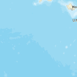


| Datetime (UTC) rmsOT_error |
Lat Smajor |
Lon Sminor |
D. (Km) AzErr |
Ndef mdist |
Nsta Mdist |
Gap | Mag1 (N) Err |
Mag2 (N) Err |
Mag3 (N) Err |
Author Quality |
|---|---|---|---|---|---|---|---|---|---|---|
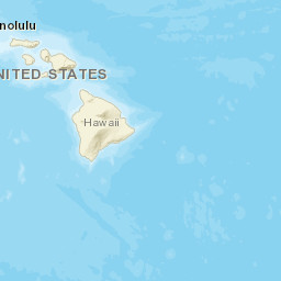
| 2025-03-22T01:58:14.55Z 0.11+/- |
19.4898 2.5 |
-155.5047 0.41 |
1.9 2981.04 |
45 0.044 |
24 0.264 |
79.1 | md 2 (9) 0.15 |
() |
() |
HV m i ke |
| Sta | Dist | EvAz | Phase | Datetime | Tres | Azim | AzRes | Slow | SRes | Def | SNR | Amp | Per | Mag1 | Mag2 |
|---|---|---|---|---|---|---|---|---|---|---|---|---|---|---|---|
| ELEP | 0.044 | 205.84 | P | 2025-03-22T01:58:16.47Z | 0.06 | ||||||||||
| ELEP | 0.044 | 205.84 | S | 2025-03-22T01:58:17.88Z | 0.07 | ||||||||||
| PLAD | 0.06 | 48.37 | P | 2025-03-22T01:58:16.5Z | -0.07 | ||||||||||
| PLAD | 0.06 | 48.37 | S | 2025-03-22T01:58:17.92Z | -0.16 | ||||||||||
| WILD | 0.076 | 252.51 | P | 2025-03-22T01:58:17.7Z | 0.15 | ||||||||||
| WILD | 0.076 | 252.51 | S | 2025-03-22T01:58:18.6Z | -0.1 | ||||||||||
| TRAD | 0.087 | 207.3 | P | 2025-03-22T01:58:17.32Z | 0.15 | ||||||||||
| TRAD | 0.087 | 207.3 | S | 2025-03-22T01:58:19.5Z | -0.08 | ||||||||||
| MOKD | 0.087 | 266.86 | P | 2025-03-22T01:58:17.14Z | 0.06 | ||||||||||
| MOKD | 0.087 | 266.86 | S | 2025-03-22T01:58:18.56Z | -0.42 | ||||||||||
| SWRD | 0.1 | 247.94 | P | 2025-03-22T01:58:17.22Z | 0.08 | ||||||||||
| SWRD | 0.1 | 247.94 | S | 2025-03-22T01:58:19.17Z | 0.09 | ||||||||||
| MLOD | 0.112 | 88.37 | P | 2025-03-22T01:58:17.49Z | -0.02 | ||||||||||
| MLOD | 0.112 | 88.37 | S | 2025-03-22T01:58:19.66Z | -0.07 | ||||||||||
| HSSD | 0.115 | 10.28 | P | 2025-03-22T01:58:17.69Z | 0.04 | ||||||||||
| HSSD | 0.115 | 10.28 | S | 2025-03-22T01:58:19.98Z | 0.01 | ||||||||||
| AIND | 0.126 | 159 | P | 2025-03-22T01:58:17.78Z | -0.05 | ||||||||||
| AIND | 0.126 | 159 | S | 2025-03-22T01:58:20.11Z | -0.18 | ||||||||||
| ALEP | 0.141 | 291.19 | P | 2025-03-22T01:58:18.8Z | -0.09 | ||||||||||
| ALEP | 0.141 | 291.19 | S | 2025-03-22T01:58:20.58Z | -0.3 | ||||||||||
| RCOD | 0.145 | 233.44 | P | 2025-03-22T01:58:17.74Z | -0.13 | ||||||||||
| RCOD | 0.145 | 233.44 | S | 2025-03-22T01:58:20.72Z | 0.36 | ||||||||||
| TOUO | 0.188 | 274.34 | P | 2025-03-22T01:58:18.82Z | 0.12 | ||||||||||
| TOUO | 0.188 | 274.34 | S | 2025-03-22T01:58:22.4Z | 0.23 | ||||||||||
| DESD | 0.192 | 144.31 | P | 2025-03-22T01:58:18.62Z | -0.05 | ||||||||||
| DESD | 0.192 | 144.31 | S | 2025-03-22T01:58:21.77Z | 0.01 | ||||||||||
| CPKD | 0.197 | 119.94 | P | 2025-03-22T01:58:18.85Z | 0.05 | ||||||||||
| CPKD | 0.197 | 119.94 | S | 2025-03-22T01:58:21.98Z | -0.01 | ||||||||||
| DAND | 0.202 | 228.08 | P | 2025-03-22T01:58:18.93Z | -0.01 | ||||||||||
| DAND | 0.202 | 228.08 | S | 2025-03-22T01:58:22.6Z | -0.17 | ||||||||||
| UWE | 0.213 | 108.72 | P | 2025-03-22T01:58:19.27Z | 0.15 | ||||||||||
| UWE | 0.213 | 108.72 | S | 2025-03-22T01:58:22.7Z | 0.15 | ||||||||||
| OBL | 0.22 | 108.9 | P | 2025-03-22T01:58:19.28Z | 0.09 | ||||||||||
| OBL | 0.22 | 108.9 | S | 2025-03-22T01:58:22.92Z | 0.25 | ||||||||||
| SDH | 0.222 | 116.51 | P | 2025-03-22T01:58:19.17Z | -0.1 | ||||||||||
| SDH | 0.222 | 116.51 | S | 2025-03-22T01:58:22.75Z | -0.06 | ||||||||||
| SBL | 0.232 | 105.6 | P | 2025-03-22T01:58:19.29Z | -0.04 | ||||||||||
| SBL | 0.232 | 105.6 | S | 2025-03-22T01:58:23.45Z | 0.53 | ||||||||||
| OTLD | 0.234 | 115.92 | P | 2025-03-22T01:58:19.33Z | -0.09 | ||||||||||
| OTLD | 0.234 | 115.92 | S | 2025-03-22T01:58:23.16Z | 0.09 | ||||||||||
| MITD | 0.246 | 128.49 | P | 2025-03-22T01:58:19.52Z | -0.08 | ||||||||||
| MITD | 0.246 | 128.49 | S | 2025-03-22T01:58:23.56Z | 0.17 | ||||||||||
| AHUD | 0.257 | 117.16 | P | 2025-03-22T01:58:19.78Z | -0.02 | ||||||||||
| KHU | 0.264 | 203.26 | P | 2025-03-22T01:58:19.87Z | -0.13 | ||||||||||
| KHU | 0.264 | 203.26 | S | 2025-03-22T01:58:24.7Z | -0.02 | ||||||||||
| Sta | Dist | EvAz | Phase | Datetime | Tres | Azim | AzRes | Slow | SRes | Def | SNR | Amp | Per | Mag1 | Mag2 |
| Centroid | Nodal Plan 1 | Nodal Plan 2 | Tensor | Moment Inf. | |||||||||||||||||
|---|---|---|---|---|---|---|---|---|---|---|---|---|---|---|---|---|---|---|---|---|---|
| Auth | Datetime | Lat | Lon | Depth | Mw | Strike | Dip | Rake | Strike | Dip | Rake | Mrr | Mtt | Mpp | Mrt | Mrp | Mtp | %DC | %ISO | %CLVD | |
| Auth | Datetime UTC | lat | lon | Depth | Mw | Strike | Dip | Rake | Strike | Dip | Rake | Mrr | Mtt | Mpp | Mrt | Mrp | Mtp | %DC | %ISO | %CLVD | |


