SeismicPortal
 is the European Infrastructure
 for seismological products in :
is the European Infrastructure 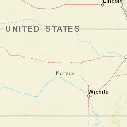


| Datetime (UTC) rmsOT_error |
Lat Smajor |
Lon Sminor |
D. (Km) AzErr |
Ndef mdist |
Nsta Mdist |
Gap | Mag1 (N) Err |
Mag2 (N) Err |
Mag3 (N) Err |
Author Quality |
|---|---|---|---|---|---|---|---|---|---|---|
| 2025-03-21T07:09:09.971Z 0.48+/- 0.97 |
39.5055 10.91 |
-98.3013 2.28 |
8.8 317.158 |
19 1.128 |
15 4.774 |
124.7 | ml 2.7 (8) 0.18 |
() |
() |
NEIC m i ke |
| Sta | Dist | EvAz | Phase | Datetime | Tres | Azim | AzRes | Slow | SRes | Def | SNR | Amp | Per | Mag1 | Mag2 |
|---|---|---|---|---|---|---|---|---|---|---|---|---|---|---|---|
| R32B | 1.128 | 196.58 | Pg | 2025-03-21T07:09:30.2Z | -0.28 | ||||||||||
| R32B | 1.128 | 196.58 | Sg | 2025-03-21T07:09:46.1Z | 1.04 | ||||||||||
| CBKS | 1.312 | 238.71 | Pg | 2025-03-21T07:09:33.9Z | -0.43 | ||||||||||
| CBKS | 1.312 | 238.71 | Sg | 2025-03-21T07:09:50.52Z | -0.11 | ||||||||||
| KSU1 | 1.373 | 106.56 | Pg | 2025-03-21T07:09:34.33Z | -0.22 | ||||||||||
| KSU1 | 1.373 | 106.56 | Sg | 2025-03-21T07:09:52.37Z | -0.05 | ||||||||||
| KS28 | 1.528 | 170.83 | Pn | 2025-03-21T07:09:36.85Z | -0.4 | ||||||||||
| KS28 | 1.528 | 170.83 | Pn | 2025-03-21T07:09:57.73Z | 0.64 | ||||||||||
| BGNE | 1.903 | 3.43 | Pn | 2025-03-21T07:09:42.9Z | 0.31 | ||||||||||
| N35B | 2.445 | 55.54 | Pn | 2025-03-21T07:09:50.37Z | 0.47 | ||||||||||
| L34B | 2.86 | 30.13 | Pn | 2025-03-21T07:09:55.35Z | -0.18 | ||||||||||
| OK051 | 3.211 | 158.42 | Pn | 2025-03-21T07:09:58.61Z | -1.66 | ||||||||||
| HTCH | 3.482 | 180.42 | Pn | 2025-03-21T07:10:03.88Z | -0.07 | ||||||||||
| DOVR | 3.554 | 175.9 | Pn | 2025-03-21T07:10:04.56Z | -0.36 | ||||||||||
| P38B | 3.687 | 86.63 | Pn | 2025-03-21T07:10:07.18Z | 0.46 | ||||||||||
| CHOK | 4.059 | 165.56 | Pn | 2025-03-21T07:10:10.84Z | -0.92 | ||||||||||
| TUL3 | 4.103 | 150.22 | Pn | 2025-03-21T07:10:11.86Z | -0.5 | ||||||||||
| ECSD | 4.409 | 16.11 | Pn | 2025-03-21T07:10:16.87Z | 0.36 | ||||||||||
| WMOK | 4.774 | 184.75 | Pn | 2025-03-21T07:10:21.68Z | 0.21 | ||||||||||
| Sta | Dist | EvAz | Phase | Datetime | Tres | Azim | AzRes | Slow | SRes | Def | SNR | Amp | Per | Mag1 | Mag2 |
| Centroid | Nodal Plan 1 | Nodal Plan 2 | Tensor | Moment Inf. | |||||||||||||||||
|---|---|---|---|---|---|---|---|---|---|---|---|---|---|---|---|---|---|---|---|---|---|
| Auth | Datetime | Lat | Lon | Depth | Mw | Strike | Dip | Rake | Strike | Dip | Rake | Mrr | Mtt | Mpp | Mrt | Mrp | Mtp | %DC | %ISO | %CLVD | |
| Auth | Datetime UTC | lat | lon | Depth | Mw | Strike | Dip | Rake | Strike | Dip | Rake | Mrr | Mtt | Mpp | Mrt | Mrp | Mtp | %DC | %ISO | %CLVD | |
