SeismicPortal
 is the European Infrastructure
 for seismological products in :
is the European Infrastructure 


| Datetime (UTC) rmsOT_error |
Lat Smajor |
Lon Sminor |
D. (Km) AzErr |
Ndef mdist |
Nsta Mdist |
Gap | Mag1 (N) Err |
Mag2 (N) Err |
Mag3 (N) Err |
Author Quality |
|---|---|---|---|---|---|---|---|---|---|---|
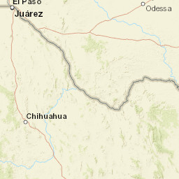
| 2025-03-20T23:27:30.62009Z 0.2+/- 0.53 |
31.721 7.88 |
-104.538 3.63 |
3.7 94.80336761474612.37760758399963 |
14 0.038 |
7 1.007 |
190.2 | ml 2 (7) 0.1 |
() |
() |
TX a i ke |
| Sta | Dist | EvAz | Phase | Datetime | Tres | Azim | AzRes | Slow | SRes | Def | SNR | Amp | Per | Mag1 | Mag2 |
|---|---|---|---|---|---|---|---|---|---|---|---|---|---|---|---|
| PB29 | 0.038 | 32.65 | P | 2025-03-20T23:27:32.23Z | 0.239 | 2176.0403234482465 | 0.02585503173573795 | ML 2.219407950298841 | |||||||
| PB29 | 0.038 | 32.65 | S | 2025-03-20T23:27:33.4Z | 0.297 | ||||||||||
| PB28 | 0.061 | 148.68 | P | 2025-03-20T23:27:32.62Z | 0.189 | 770.5990633984889 | 0.008690724900185444 | ML 2.041719600346128 | |||||||
| PB28 | 0.061 | 148.68 | S | 2025-03-20T23:27:33.71Z | 0.206 | ||||||||||
| PB36 | 0.104 | 113 | P | 2025-03-20T23:27:33.18Z | -0.038 | 680.91589134308 | 0.00427186918494732 | ML 2.135433764262444 | |||||||
| PB36 | 0.104 | 113 | S | 2025-03-20T23:27:34.68Z | -0.185 | ||||||||||
| PB35 | 0.111 | 125.53 | P | 2025-03-20T23:27:33.37Z | 0.016 | 393.31651156351415 | 0.0022666026537781435 | ML 1.9161544282326914 | |||||||
| PB35 | 0.111 | 125.53 | S | 2025-03-20T23:27:34.92Z | -0.179 | ||||||||||
| SA07 | 0.206 | 45.53 | P | 2025-03-20T23:27:35.37Z | -0.075 | 65.28765192003482 | 0.0006312914439711943 | ML 1.807996905582838 | |||||||
| SA07 | 0.206 | 45.53 | S | 2025-03-20T23:27:37.747Z | -0.393 | ||||||||||
| PB12 | 0.709 | 135.47 | P | 2025-03-20T23:27:44.465Z | 0.054 | 19.00511817535829 | 0.0002357576518162794 | ML 2.2094939245459972 | |||||||
| PB12 | 0.709 | 135.47 | S | 2025-03-20T23:27:54.435Z | 0.212 | ||||||||||
| VHRN | 1.007 | 202.47 | P | 2025-03-20T23:27:49.68Z | -0.243 | 6.068526989590848 | 0.00005980170926905909 | ML 1.9134810830459805 | |||||||
| VHRN | 1.007 | 202.47 | S | 2025-03-20T23:28:03.67Z | -0.099 | ||||||||||
| Sta | Dist | EvAz | Phase | Datetime | Tres | Azim | AzRes | Slow | SRes | Def | SNR | Amp | Per | Mag1 | Mag2 |
| Centroid | Nodal Plan 1 | Nodal Plan 2 | Tensor | Moment Inf. | |||||||||||||||||
|---|---|---|---|---|---|---|---|---|---|---|---|---|---|---|---|---|---|---|---|---|---|
| Auth | Datetime | Lat | Lon | Depth | Mw | Strike | Dip | Rake | Strike | Dip | Rake | Mrr | Mtt | Mpp | Mrt | Mrp | Mtp | %DC | %ISO | %CLVD | |
| Auth | Datetime UTC | lat | lon | Depth | Mw | Strike | Dip | Rake | Strike | Dip | Rake | Mrr | Mtt | Mpp | Mrt | Mrp | Mtp | %DC | %ISO | %CLVD | |

