SeismicPortal
 is the European Infrastructure
 for seismological products in :
is the European Infrastructure 


| Datetime (UTC) rmsOT_error |
Lat Smajor |
Lon Sminor |
D. (Km) AzErr |
Ndef mdist |
Nsta Mdist |
Gap | Mag1 (N) Err |
Mag2 (N) Err |
Mag3 (N) Err |
Author Quality |
|---|---|---|---|---|---|---|---|---|---|---|
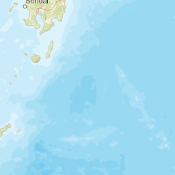
| 2025-03-19T05:11:32.9Z +/- |
28.98 |
141.44 |
10 |
21 8.022 |
21 78.525 |
135.9 | mb 4.5 () |
() |
() |
GSRAS m i ke |
| Sta | Dist | EvAz | Phase | Datetime | Tres | Azim | AzRes | Slow | SRes | Def | SNR | Amp | Per | Mag1 | Mag2 |
|---|---|---|---|---|---|---|---|---|---|---|---|---|---|---|---|
| MAJO | 8.022 | 340.99 | P | 2025-03-19T05:13:29.0Z | 0 | ||||||||||
| KLR | 21.535 | 342.52 | P | 2025-03-19T05:16:21.0Z | 0 | ||||||||||
| ZEA | 26.82 | 341.19 | P | 2025-03-19T05:17:11.8Z | 0 | ||||||||||
| ULN | 32.51 | 315.01 | P | 2025-03-19T05:18:05.3Z | 0 | ||||||||||
| SEY | 34.678 | 8.76 | P | 2025-03-19T05:18:24.8Z | 0 | ||||||||||
| ZAK | 35.762 | 317.46 | P | 2025-03-19T05:18:33.3Z | 0 | ||||||||||
| ORL | 38.573 | 319.46 | P | 2025-03-19T05:18:57.1Z | 0 | ||||||||||
| CHTO | 39.986 | 265.07 | P | 2025-03-19T05:19:09.9Z | 0 | ||||||||||
| DGZ | 45.485 | 312.62 | P | 2025-03-19T05:19:52.9Z | 0 | ||||||||||
| ZALV | 47.621 | 318.15 | P | 2025-03-19T05:20:10.0Z | 0 | ||||||||||
| MK31 | 48.767 | 308.43 | P | 2025-03-19T05:20:19.0Z | 0 | ||||||||||
| MKAR | 48.768 | 308.43 | P | 2025-03-19T05:20:18.8Z | 0 | ||||||||||
| WRA | 48.982 | 188.82 | P | 2025-03-19T05:20:19.6Z | 0 | ||||||||||
| WRAB | 49.151 | 188.83 | P | 2025-03-19T05:20:19.4Z | 0 | ||||||||||
| NRIK | 50.616 | 338.28 | P | 2025-03-19T05:20:30.4Z | 0 | ||||||||||
| KURK | 51.185 | 313.56 | P | 2025-03-19T05:20:36.5Z | 0 | ||||||||||
| BORK | 56.231 | 316.69 | P | 2025-03-19T05:21:13.4Z | 0 | ||||||||||
| JZAX | 60.152 | 302 | P | 2025-03-19T05:21:39.4Z | 0 | ||||||||||
| YKA | 70.682 | 28.31 | P | 2025-03-19T05:22:50.9Z | 0 | ||||||||||
| MOY | 78.525 | 52.92 | P | 2025-03-19T05:18:48.2Z | 0 | ||||||||||
| Sta | Dist | EvAz | Phase | Datetime | Tres | Azim | AzRes | Slow | SRes | Def | SNR | Amp | Per | Mag1 | Mag2 |
| Centroid | Nodal Plan 1 | Nodal Plan 2 | Tensor | Moment Inf. | |||||||||||||||||
|---|---|---|---|---|---|---|---|---|---|---|---|---|---|---|---|---|---|---|---|---|---|
| Auth | Datetime | Lat | Lon | Depth | Mw | Strike | Dip | Rake | Strike | Dip | Rake | Mrr | Mtt | Mpp | Mrt | Mrp | Mtp | %DC | %ISO | %CLVD | |
| Auth | Datetime UTC | lat | lon | Depth | Mw | Strike | Dip | Rake | Strike | Dip | Rake | Mrr | Mtt | Mpp | Mrt | Mrp | Mtp | %DC | %ISO | %CLVD | |


