SeismicPortal
 is the European Infrastructure
 for seismological products in :
is the European Infrastructure 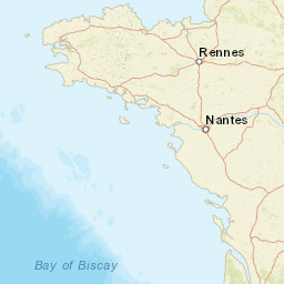


| Datetime (UTC) rmsOT_error |
Lat Smajor |
Lon Sminor |
D. (Km) AzErr |
Ndef mdist |
Nsta Mdist |
Gap | Mag1 (N) Err |
Mag2 (N) Err |
Mag3 (N) Err |
Author Quality |
|---|---|---|---|---|---|---|---|---|---|---|
| 2025-02-18T12:42:21.263177Z 0.9+/- 0.25 |
45.3155 |
1.4177 |
5 0 |
20 0.07 |
19 2.765 |
68.8 | ml 2.2 (14) 0.14 |
() |
() |
ReNaSS a i ke |
| Sta | Dist | EvAz | Phase | Datetime | Tres | Azim | AzRes | Slow | SRes | Def | SNR | Amp | Per | Mag1 | Mag2 |
|---|---|---|---|---|---|---|---|---|---|---|---|---|---|---|---|
| RJF | 0.07 | 99.37 | P | 2025-02-18T12:42:20.98Z | -2.014 | ||||||||||
| FR15A | 0.247 | 258.42 | P | 2025-02-18T12:42:24.99Z | -1.046 | ||||||||||
| ABJF | 0.529 | 299.45 | P | 2025-02-18T12:42:29.83Z | -1.44 | ||||||||||
| FR17A | 0.618 | 105.69 | P | 2025-02-18T12:42:31.69Z | -1.226 | ||||||||||
| FR10A | 0.761 | 331.39 | P | 2025-02-18T12:42:36.81Z | 1.24 | ||||||||||
| FRNF | 0.81 | 84.67 | P | 2025-02-18T12:42:36.25Z | -0.243 | ||||||||||
| VERF | 0.865 | 59.55 | P | 2025-02-18T12:42:37.88Z | 0.372 | ||||||||||
| MONQ | 0.96 | 189.57 | P | 2025-02-18T12:42:40.2005Z | 0.909 | ||||||||||
| MONQ | 0.96 | 189.57 | P | 2025-02-18T12:42:40.3705Z | 1.079 | ||||||||||
| LEUC | 0.977 | 124.13 | P | 2025-02-18T12:42:39.17Z | -0.443 | ||||||||||
| GZNF | 1.018 | 32.29 | P | 2025-02-18T12:42:40.8Z | -0.282 | ||||||||||
| CMPS | 1.073 | 83.07 | P | 2025-02-18T12:42:41.43Z | 0.038 | ||||||||||
| GNEF | 1.097 | 316.38 | P | 2025-02-18T12:42:42.1Z | 0.177 | ||||||||||
| GARF | 1.205 | 5.7 | P | 2025-02-18T12:42:43.55Z | 0.017 | ||||||||||
| SLVF | 1.243 | 154.43 | P | 2025-02-18T12:42:44.12Z | 0.071 | ||||||||||
| LBL | 1.294 | 93.05 | P | 2025-02-18T12:42:44.59Z | -0.133 | ||||||||||
| SGSF | 1.579 | 98.99 | P | 2025-02-18T12:42:49.9Z | 0.488 | ||||||||||
| COLF | 1.613 | 82.63 | P | 2025-02-18T12:42:50.71Z | 1.631 | ||||||||||
| CLF | 2.765 | 11.8 | P | 2025-02-18T12:43:05.47Z | 0.684 | ||||||||||
| Sta | Dist | EvAz | Phase | Datetime | Tres | Azim | AzRes | Slow | SRes | Def | SNR | Amp | Per | Mag1 | Mag2 |
| Centroid | Nodal Plan 1 | Nodal Plan 2 | Tensor | Moment Inf. | |||||||||||||||||
|---|---|---|---|---|---|---|---|---|---|---|---|---|---|---|---|---|---|---|---|---|---|
| Auth | Datetime | Lat | Lon | Depth | Mw | Strike | Dip | Rake | Strike | Dip | Rake | Mrr | Mtt | Mpp | Mrt | Mrp | Mtp | %DC | %ISO | %CLVD | |
| Auth | Datetime UTC | lat | lon | Depth | Mw | Strike | Dip | Rake | Strike | Dip | Rake | Mrr | Mtt | Mpp | Mrt | Mrp | Mtp | %DC | %ISO | %CLVD | |

