SeismicPortal
 is the European Infrastructure
 for seismological products in :
is the European Infrastructure 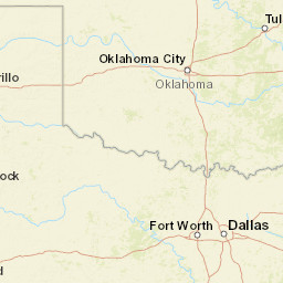


| Datetime (UTC) rmsOT_error |
Lat Smajor |
Lon Sminor |
D. (Km) AzErr |
Ndef mdist |
Nsta Mdist |
Gap | Mag1 (N) Err |
Mag2 (N) Err |
Mag3 (N) Err |
Author Quality |
|---|---|---|---|---|---|---|---|---|---|---|
| 2025-02-10T23:18:30.304335Z 0.67+/- 0.28 |
35.1037 2346.86 |
-97.5704 1708.32 |
3.3 56.803498771.415026135 |
82 0.189 |
43 1.525 |
51 | ml 2.4 (32) 0.32 |
() |
() |
OK a i ke |
| Sta | Dist | EvAz | Phase | Datetime | Tres | Azim | AzRes | Slow | SRes | Def | SNR | Amp | Per | Mag1 | Mag2 |
|---|---|---|---|---|---|---|---|---|---|---|---|---|---|---|---|
| SC17 | 0.189 | 186.9 | P | 2025-02-10T23:18:33.954999Z | -0.476 | ML 2.450661293 | |||||||||
| SC17 | 0.189 | 186.9 | S | 2025-02-10T23:18:35.714999Z | -1.406 | ||||||||||
| TUTT | 0.203 | 311.45 | P | 2025-02-10T23:18:34.315Z | -0.372 | ML 2.759398084 | |||||||||
| TUTT | 0.203 | 311.45 | S | 2025-02-10T23:18:37.705Z | 0.141 | ||||||||||
| FNO | 0.207 | 42.17 | P | 2025-02-10T23:18:35.199999Z | 0.436 | ML 2.328094983 | |||||||||
| FNO | 0.207 | 42.17 | S | 2025-02-10T23:18:37.659999Z | -0.038 | ||||||||||
| SC01 | 0.22 | 291.71 | P | 2025-02-10T23:18:34.924999Z | -0.086 | ML 2.768732226 | |||||||||
| SC01 | 0.22 | 291.71 | S | 2025-02-10T23:18:41.364999Z | 3.24 | ||||||||||
| MOOR | 0.249 | 343.07 | P | 2025-02-10T23:18:35.49Z | -0.048 | ML 2.179146033 | |||||||||
| TG11 | 0.259 | 309.57 | P | 2025-02-10T23:18:35.879999Z | 0.143 | ML 3.00074303 | |||||||||
| TG11 | 0.259 | 309.57 | S | 2025-02-10T23:18:37.989999Z | -1.391 | ||||||||||
| SC03 | 0.281 | 234.54 | P | 2025-02-10T23:18:35.63Z | -0.51 | ML 2.423362427 | |||||||||
| SC03 | 0.281 | 234.54 | S | 2025-02-10T23:18:39.28Z | -0.798 | ||||||||||
| SC02 | 0.339 | 153.9 | P | 2025-02-10T23:18:37.43Z | 0.198 | ||||||||||
| SC02 | 0.339 | 153.9 | S | 2025-02-10T23:18:42.19Z | 0.221 | ||||||||||
| UCTY | 0.402 | 315.39 | P | 2025-02-10T23:18:40.97Z | 2.58 | ML 2.689019426 | |||||||||
| POCA | 0.429 | 285.57 | P | 2025-02-10T23:18:38.929999Z | 0.041 | ML 2.512423424 | |||||||||
| POCA | 0.429 | 285.57 | S | 2025-02-10T23:18:44.999999Z | 0.165 | ||||||||||
| ERNS | 0.493 | 310.55 | P | 2025-02-10T23:18:40.69Z | 0.609 | ML 2.417184525 | |||||||||
| ERNS | 0.493 | 310.55 | S | 2025-02-10T23:18:46.67Z | -0.228 | ||||||||||
| YUKO | 0.494 | 331.4 | P | 2025-02-10T23:18:40.184999Z | 0.084 | ||||||||||
| YUKO | 0.494 | 331.4 | S | 2025-02-10T23:18:46.874999Z | -0.059 | ||||||||||
| SHWN | 0.508 | 61.8 | P | 2025-02-10T23:18:40.319999Z | -0.035 | ML 1.685113553 | |||||||||
| SHWN | 0.508 | 61.8 | S | 2025-02-10T23:18:47.769999Z | 0.397 | ||||||||||
| X34A | 0.546 | 203.37 | P | 2025-02-10T23:18:41.12Z | 0.062 | ML 2.286193788 | |||||||||
| X34A | 0.546 | 203.37 | S | 2025-02-10T23:18:49.27Z | 0.681 | ||||||||||
| BLUF | 0.553 | 356.74 | P | 2025-02-10T23:18:42.115Z | 0.933 | ML 1.859239277 | |||||||||
| BLUF | 0.553 | 356.74 | S | 2025-02-10T23:18:48.845Z | 0.041 | ||||||||||
| W35A | 0.573 | 84.87 | P | 2025-02-10T23:18:41.374999Z | -0.177 | ||||||||||
| W35A | 0.573 | 84.87 | S | 2025-02-10T23:18:49.694999Z | 0.251 | ||||||||||
| SC09 | 0.582 | 163.15 | P | 2025-02-10T23:18:41.469999Z | -0.261 | ML 2.172861631 | |||||||||
| SC09 | 0.582 | 163.15 | S | 2025-02-10T23:18:49.919999Z | 0.165 | ||||||||||
| CHOK | 0.618 | 42.24 | P | 2025-02-10T23:18:42.485Z | 0.095 | ML 2.361830858 | |||||||||
| CHOK | 0.618 | 42.24 | S | 2025-02-10T23:18:51.255Z | 0.361 | ||||||||||
| ARC2 | 0.683 | 20.83 | P | 2025-02-10T23:18:43.33Z | -0.267 | ML 2.224390497 | |||||||||
| ARC2 | 0.683 | 20.83 | S | 2025-02-10T23:18:53.11Z | 0.127 | ||||||||||
| SC20 | 0.773 | 292.99 | P | 2025-02-10T23:18:45.49Z | 0.231 | ||||||||||
| SC20 | 0.773 | 292.99 | S | 2025-02-10T23:18:56.7Z | 0.841 | ||||||||||
| CHAN | 0.844 | 49.28 | P | 2025-02-10T23:18:46.634999Z | 0.053 | ML 2.675339719 | |||||||||
| CHAN | 0.844 | 49.28 | S | 2025-02-10T23:18:58.174999Z | 0.026 | ||||||||||
| SMNL | 0.845 | 76.72 | P | 2025-02-10T23:18:46.33Z | -0.279 | ||||||||||
| SMNL | 0.845 | 76.72 | S | 2025-02-10T23:18:57.99Z | -0.206 | ||||||||||
| PERK | 0.896 | 23.52 | P | 2025-02-10T23:18:47.314999Z | -0.236 | ML 2.400426364 | |||||||||
| PERK | 0.896 | 23.52 | S | 2025-02-10T23:18:59.814999Z | -0.011 | ||||||||||
| DOVR | 0.914 | 338.25 | P | 2025-02-10T23:18:47.85Z | -0.047 | ML 2.194975744 | |||||||||
| DOVR | 0.914 | 338.25 | S | 2025-02-10T23:18:59.78Z | -0.646 | ||||||||||
| WADE | 0.953 | 182.43 | P | 2025-02-10T23:18:48.144999Z | -0.474 | ||||||||||
| WADE | 0.953 | 182.43 | S | 2025-02-10T23:19:01.564999Z | -0.11 | ||||||||||
| MRSH | 1.031 | 354.39 | P | 2025-02-10T23:18:49.71Z | -0.281 | ML 2.57482175 | |||||||||
| MRSH | 1.031 | 354.39 | S | 2025-02-10T23:19:03.66Z | -0.437 | ||||||||||
| TISH | 1.074 | 127.77 | P | 2025-02-10T23:18:50.774999Z | 0.099 | ML 2.560991853 | |||||||||
| TISH | 1.074 | 127.77 | S | 2025-02-10T23:19:05.74999Z | -0.273 | ||||||||||
| HTCH | 1.103 | 325.92 | P | 2025-02-10T23:18:50.77Z | -0.378 | ||||||||||
| HTCH | 1.103 | 325.92 | S | 2025-02-10T23:19:05.46Z | -0.749 | ||||||||||
| SC19 | 1.136 | 348.81 | P | 2025-02-10T23:18:51.26Z | -0.414 | ML 2.474609551 | |||||||||
| SC19 | 1.136 | 348.81 | S | 2025-02-10T23:19:06.56Z | -0.609 | ||||||||||
| DEOK | 1.145 | 49.57 | P | 2025-02-10T23:18:51.36Z | -0.449 | ||||||||||
| LOOK | 1.155 | 163.69 | P | 2025-02-10T23:18:52.245Z | 0.271 | ||||||||||
| LOOK | 1.155 | 163.69 | S | 2025-02-10T23:19:08.545Z | 0.827 | ||||||||||
| DUST | 1.21 | 81.22 | P | 2025-02-10T23:18:52.774999Z | -0.084 | ML 2.172305078 | |||||||||
| DUST | 1.21 | 81.22 | S | 2025-02-10T23:19:09.494999Z | 0.164 | ||||||||||
| PW18 | 1.249 | 19.92 | P | 2025-02-10T23:18:53.32Z | -0.147 | ML 2.566984205 | |||||||||
| QUOK | 1.276 | 33.16 | P | 2025-02-10T23:18:53.66Z | -0.243 | ML 3.029908456 | |||||||||
| QUOK | 1.276 | 33.16 | S | 2025-02-10T23:19:11.15Z | -0.084 | ||||||||||
| PW17 | 1.341 | 31.64 | P | 2025-02-10T23:18:54.695Z | -0.238 | ML 2.649758667 | |||||||||
| PW17 | 1.341 | 31.64 | S | 2025-02-10T23:19:13.85Z | -0.024 | ||||||||||
| PW10 | 1.396 | 25.31 | P | 2025-02-10T23:18:55.499999Z | -0.275 | ML 2.025387454 | |||||||||
| PW10 | 1.396 | 25.31 | S | 2025-02-10T23:19:14.679999Z | 0.039 | ||||||||||
| PW06 | 1.402 | 20.14 | P | 2025-02-10T23:18:55.88Z | 0.012 | ML 2.38305839 | |||||||||
| PW06 | 1.402 | 20.14 | S | 2025-02-10T23:19:15.33Z | 0.519 | ||||||||||
| CROK | 1.438 | 346.63 | P | 2025-02-10T23:18:56.395Z | -0.038 | ML 2.700273662 | |||||||||
| CROK | 1.438 | 346.63 | S | 2025-02-10T23:19:16.415Z | 0.576 | ||||||||||
| PW30 | 1.445 | 24.7 | P | 2025-02-10T23:18:56.47Z | -0.074 | ||||||||||
| PW30 | 1.445 | 24.7 | S | 2025-02-10T23:19:16.18Z | 0.138 | ||||||||||
| PW19 | 1.525 | 16.38 | P | 2025-02-10T23:18:57.895Z | 0.116 | ||||||||||
| PW19 | 1.525 | 16.38 | S | 2025-02-10T23:19:18.945Z | 0.657 | ||||||||||
| Sta | Dist | EvAz | Phase | Datetime | Tres | Azim | AzRes | Slow | SRes | Def | SNR | Amp | Per | Mag1 | Mag2 |
| Centroid | Nodal Plan 1 | Nodal Plan 2 | Tensor | Moment Inf. | |||||||||||||||||
|---|---|---|---|---|---|---|---|---|---|---|---|---|---|---|---|---|---|---|---|---|---|
| Auth | Datetime | Lat | Lon | Depth | Mw | Strike | Dip | Rake | Strike | Dip | Rake | Mrr | Mtt | Mpp | Mrt | Mrp | Mtp | %DC | %ISO | %CLVD | |
| Auth | Datetime UTC | lat | lon | Depth | Mw | Strike | Dip | Rake | Strike | Dip | Rake | Mrr | Mtt | Mpp | Mrt | Mrp | Mtp | %DC | %ISO | %CLVD | |
