SeismicPortal
 is the European Infrastructure
 for seismological products in :
is the European Infrastructure 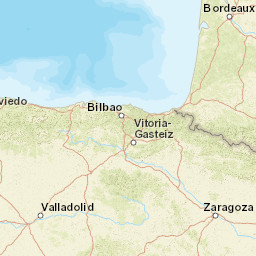


| Datetime (UTC) rmsOT_error |
Lat Smajor |
Lon Sminor |
D. (Km) AzErr |
Ndef mdist |
Nsta Mdist |
Gap | Mag1 (N) Err |
Mag2 (N) Err |
Mag3 (N) Err |
Author Quality |
|---|---|---|---|---|---|---|---|---|---|---|
| 2025-01-17T22:10:25.8Z 0.7+/- 0.61 |
43.1172 4.6 |
-1.5112 3.5 |
11.6 1672 |
12 0.102 |
8 1.411 |
91.1 | ml 1.6 (11) 0.2 |
() |
() |
IGN m i ke |
| Sta | Dist | EvAz | Phase | Datetime | Tres | Azim | AzRes | Slow | SRes | Def | SNR | Amp | Per | Mag1 | Mag2 |
|---|---|---|---|---|---|---|---|---|---|---|---|---|---|---|---|
| EALK | 0.102 | 1.68 | Pg | 2025-01-17T22:10:28.149Z | -0.3 | ||||||||||
| EALK | 0.102 | 1.68 | Sg | 2025-01-17T22:10:30.488Z | 0 | 0.0000020118 | ML 1.6 | ||||||||
| EORO | 0.269 | 146.54 | Pg | 2025-01-17T22:10:30.468Z | -0.6 | ||||||||||
| EORO | 0.269 | 146.54 | Sg | 2025-01-17T22:10:34.393Z | -0.6 | 3.891e-7 | ML 1.3 | ||||||||
| ATE | 0.595 | 92.73 | Pg | 2025-01-17T22:10:36.537Z | -0.2 | ||||||||||
| ATE | 0.595 | 92.73 | Sg | 2025-01-17T22:10:44.662Z | -0.2 | ||||||||||
| SC28 | 1.022 | 213.4 | Sg | 2025-01-17T22:10:58.755Z | 0.7 | 1.3730000000000002e-7 | ML 1.6 | ||||||||
| SV02 | 1.06 | 228.22 | Sg | 2025-01-17T22:11:00.128Z | 0.9 | 8.8e-8 | ML 1.4 | ||||||||
| SC27 | 1.268 | 231.31 | IVmb_Lg | 2025-01-17T22:11:03.625Z | 7.68e-8 | ML 1.4 | |||||||||
| SC27 | 1.268 | 231.31 | Sg | 2025-01-17T22:11:04.581Z | -1 | ||||||||||
| ECHI | 1.332 | 109.26 | Pg | 2025-01-17T22:10:50.804Z | 1.2 | ||||||||||
| ECHI | 1.332 | 109.26 | Sg | 2025-01-17T22:11:07.428Z | -0.2 | 1.224e-7 | ML 1.7 | ||||||||
| ELAN | 1.411 | 275.31 | Sg | 2025-01-17T22:11:09.557Z | -0.4 | 2.156e-7 | ML 2 | ||||||||
| Sta | Dist | EvAz | Phase | Datetime | Tres | Azim | AzRes | Slow | SRes | Def | SNR | Amp | Per | Mag1 | Mag2 |
| Centroid | Nodal Plan 1 | Nodal Plan 2 | Tensor | Moment Inf. | |||||||||||||||||
|---|---|---|---|---|---|---|---|---|---|---|---|---|---|---|---|---|---|---|---|---|---|
| Auth | Datetime | Lat | Lon | Depth | Mw | Strike | Dip | Rake | Strike | Dip | Rake | Mrr | Mtt | Mpp | Mrt | Mrp | Mtp | %DC | %ISO | %CLVD | |
| Auth | Datetime UTC | lat | lon | Depth | Mw | Strike | Dip | Rake | Strike | Dip | Rake | Mrr | Mtt | Mpp | Mrt | Mrp | Mtp | %DC | %ISO | %CLVD | |

