SeismicPortal
 is the European Infrastructure
 for seismological products in :
is the European Infrastructure 


| Datetime (UTC) rmsOT_error |
Lat Smajor |
Lon Sminor |
D. (Km) AzErr |
Ndef mdist |
Nsta Mdist |
Gap | Mag1 (N) Err |
Mag2 (N) Err |
Mag3 (N) Err |
Author Quality |
|---|---|---|---|---|---|---|---|---|---|---|
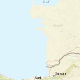
| 2025-01-13T15:28:29.0Z 0.27+/- |
38.2836 |
38.7156 |
7 |
20 0.162 |
10 0.704 |
124.1 | ml 1.1 () |
() |
() |
AFAD m i ke |
| Sta | Dist | EvAz | Phase | Datetime | Tres | Azim | AzRes | Slow | SRes | Def | SNR | Amp | Per | Mag1 | Mag2 |
|---|---|---|---|---|---|---|---|---|---|---|---|---|---|---|---|
| MGUN | 0.162 | 136.07 | S | 2025-01-13T15:28:33.61Z | 0.02 | ||||||||||
| MGUN | 0.162 | 136.07 | P | 2025-01-13T15:28:33.61Z | 0.14 | ||||||||||
| MAYA | 0.232 | 280.42 | S | 2025-01-13T15:28:34.75Z | 0.3 | ||||||||||
| MAYA | 0.232 | 280.42 | P | 2025-01-13T15:28:34.75Z | -0.04 | ||||||||||
| ELZG | 0.3 | 44.5 | S | 2025-01-13T15:28:36.2Z | 0.28 | ||||||||||
| ELZG | 0.3 | 44.5 | P | 2025-01-13T15:28:36.2Z | 0.28 | ||||||||||
| MYES | 0.396 | 218.48 | S | 2025-01-13T15:28:37.89Z | 0.01 | ||||||||||
| MYES | 0.396 | 218.48 | P | 2025-01-13T15:28:37.89Z | 0.02 | ||||||||||
| NARI | 0.401 | 174.83 | S | 2025-01-13T15:28:38.84Z | 0.3 | ||||||||||
| NARI | 0.401 | 174.83 | P | 2025-01-13T15:28:38.84Z | 0.94 | ||||||||||
| CNG | 0.465 | 100.79 | S | 2025-01-13T15:28:38.47Z | -0.56 | ||||||||||
| CNG | 0.465 | 100.79 | P | 2025-01-13T15:28:38.47Z | -0.52 | ||||||||||
| MSAY | 0.495 | 51.63 | S | 2025-01-13T15:28:39.11Z | 0.15 | ||||||||||
| MSAY | 0.495 | 51.63 | P | 2025-01-13T15:28:39.11Z | -0.4 | ||||||||||
| MDUR | 0.615 | 75.83 | S | 2025-01-13T15:28:41.61Z | 0.27 | ||||||||||
| MDUR | 0.615 | 75.83 | P | 2025-01-13T15:28:41.61Z | -0.15 | ||||||||||
| AKCD | 0.624 | 271.38 | S | 2025-01-13T15:28:41.91Z | -0.39 | ||||||||||
| AKCD | 0.624 | 271.38 | P | 2025-01-13T15:28:41.91Z | -0.11 | ||||||||||
| MTOP | 0.704 | 255.03 | S | 2025-01-13T15:28:43.27Z | 0.27 | ||||||||||
| MTOP | 0.704 | 255.03 | P | 2025-01-13T15:28:43.27Z | -0.27 | ||||||||||
| Sta | Dist | EvAz | Phase | Datetime | Tres | Azim | AzRes | Slow | SRes | Def | SNR | Amp | Per | Mag1 | Mag2 |
| Centroid | Nodal Plan 1 | Nodal Plan 2 | Tensor | Moment Inf. | |||||||||||||||||
|---|---|---|---|---|---|---|---|---|---|---|---|---|---|---|---|---|---|---|---|---|---|
| Auth | Datetime | Lat | Lon | Depth | Mw | Strike | Dip | Rake | Strike | Dip | Rake | Mrr | Mtt | Mpp | Mrt | Mrp | Mtp | %DC | %ISO | %CLVD | |
| Auth | Datetime UTC | lat | lon | Depth | Mw | Strike | Dip | Rake | Strike | Dip | Rake | Mrr | Mtt | Mpp | Mrt | Mrp | Mtp | %DC | %ISO | %CLVD | |

