SeismicPortal
 is the European Infrastructure
 for seismological products in :
is the European Infrastructure 
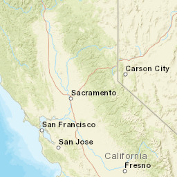


| Datetime (UTC) rmsOT_error |
Lat Smajor |
Lon Sminor |
D. (Km) AzErr |
Ndef mdist |
Nsta Mdist |
Gap | Mag1 (N) Err |
Mag2 (N) Err |
Mag3 (N) Err |
Author Quality |
|---|---|---|---|---|---|---|---|---|---|---|
| 2024-12-14T14:35:27.428Z 0.42+/- 0.85 |
40.4164 7.98 |
-125.1108 1.47 |
10 3291.929 |
11 0.756 |
11 2.291 |
273.9 | ml 2.7 (36) 0.06 |
() |
() |
NEIC m i ke |
| Sta | Dist | EvAz | Phase | Datetime | Tres | Azim | AzRes | Slow | SRes | Def | SNR | Amp | Per | Mag1 | Mag2 |
|---|---|---|---|---|---|---|---|---|---|---|---|---|---|---|---|
| KMPB | 0.756 | 89.62 | Pg | 2024-12-14T14:35:43.6Z | 1.02 | 2.32333e-7 | 0.39 | ML 2.58 | |||||||
| JCC | 0.915 | 63.65 | Pg | 2024-12-14T14:35:45.56Z | 0.51 | 2.49614e-7 | 0.25 | ML 2.73 | |||||||
| KMR | 1.093 | 100.83 | Pg | 2024-12-14T14:35:48.49Z | 0.03 | 2.77476e-7 | 1.74 | ML 2.9 | |||||||
| KRP | 1.109 | 47.76 | Pn | 2024-12-14T14:35:48.75Z | -0.35 | ||||||||||
| KHMB | 1.144 | 65.97 | Pn | 2024-12-14T14:35:49.39Z | -0.27 | 1.88133e-7 | 4.69 | ML 2.76 | |||||||
| HALS | 1.22 | 119.11 | Pn | 2024-12-14T14:35:49.95Z | -0.63 | ||||||||||
| KHBB | 1.461 | 79.81 | Pn | 2024-12-14T14:35:53.63Z | -0.43 | 6.90824e-8 | 4.29 | ML 2.51 | |||||||
| KSXB | 1.692 | 33.02 | Pn | 2024-12-14T14:35:57.32Z | 0.16 | ||||||||||
| PETY | 1.792 | 96.91 | Pn | 2024-12-14T14:35:58.25Z | -0.25 | 4.93538e-8 | 4.775 | ML 2.53 | |||||||
| SBAR | 1.982 | 50.43 | Pn | 2024-12-14T14:36:00.76Z | -0.42 | 5.06242e-8 | 4.7 | ML 2.63 | |||||||
| GUMB | 2.128 | 67.2 | Pn | 2024-12-14T14:36:03.42Z | 0.19 | 3.05853e-8 | 4.925 | ML 2.48 | |||||||
| YBH | 2.24 | 53.31 | Pn | 2024-12-14T14:36:04.97Z | 0.29 | 5.07896e-8 | 4.925 | ML 2.75 | |||||||
| LCOW | 2.241 | 83.25 | Pn | 2024-12-14T14:36:04.69Z | 0.1 | 3.60143e-8 | 4.275 | ML 2.6 | |||||||
| LTC | 2.291 | 94.24 | Pn | 2024-12-14T14:36:05.18Z | -0.11 | 1.14061e-7 | 4.22 | ML 3.12 | |||||||
| Sta | Dist | EvAz | Phase | Datetime | Tres | Azim | AzRes | Slow | SRes | Def | SNR | Amp | Per | Mag1 | Mag2 |
| Centroid | Nodal Plan 1 | Nodal Plan 2 | Tensor | Moment Inf. | |||||||||||||||||
|---|---|---|---|---|---|---|---|---|---|---|---|---|---|---|---|---|---|---|---|---|---|
| Auth | Datetime | Lat | Lon | Depth | Mw | Strike | Dip | Rake | Strike | Dip | Rake | Mrr | Mtt | Mpp | Mrt | Mrp | Mtp | %DC | %ISO | %CLVD | |
| Auth | Datetime UTC | lat | lon | Depth | Mw | Strike | Dip | Rake | Strike | Dip | Rake | Mrr | Mtt | Mpp | Mrt | Mrp | Mtp | %DC | %ISO | %CLVD | |

