SeismicPortal
 is the European Infrastructure
 for seismological products in :
is the European Infrastructure 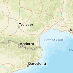


| Datetime (UTC) rmsOT_error |
Lat Smajor |
Lon Sminor |
D. (Km) AzErr |
Ndef mdist |
Nsta Mdist |
Gap | Mag1 (N) Err |
Mag2 (N) Err |
Mag3 (N) Err |
Author Quality |
|---|---|---|---|---|---|---|---|---|---|---|
| 2024-12-10T11:07:40.116565Z 0.83+/- 0.3 |
42.5802 |
2.7331 |
0 0 |
18 0.145 |
18 2.205 |
105 | ml 2.1 (14) 0.3 |
() |
() |
ReNaSS a i ke |
| Sta | Dist | EvAz | Phase | Datetime | Tres | Azim | AzRes | Slow | SRes | Def | SNR | Amp | Per | Mag1 | Mag2 |
|---|---|---|---|---|---|---|---|---|---|---|---|---|---|---|---|
| SJAF | 0.145 | 130.78 | P | 2024-12-10T11:07:42.7505Z | -0.247 | ||||||||||
| EJON | 0.175 | 138.62 | P | 2024-12-10T11:07:43.48Z | -0.084 | ||||||||||
| FILF | 0.234 | 265.17 | P | 2024-12-10T11:07:43.620502Z | -1.109 | ||||||||||
| CBEU | 0.327 | 187.45 | P | 2024-12-10T11:07:46.7Z | 0.211 | ||||||||||
| CPAL | 0.417 | 130.24 | P | 2024-12-10T11:07:47.72Z | -0.436 | ||||||||||
| CARF | 0.482 | 286.43 | P | 2024-12-10T11:07:48.340501Z | -1.046 | ||||||||||
| CBRU | 0.506 | 234.37 | P | 2024-12-10T11:07:49.52Z | -0.291 | ||||||||||
| VALC | 0.547 | 249.7 | P | 2024-12-10T11:07:50.5Z | -0.088 | ||||||||||
| FNEB | 0.563 | 305.14 | P | 2024-12-10T11:07:50.110499Z | -0.773 | ||||||||||
| CLLI | 0.571 | 259.96 | P | 2024-12-10T11:07:50.43Z | -0.599 | ||||||||||
| CLAF | 0.613 | 25.21 | P | 2024-12-10T11:07:51.63Z | -0.188 | ||||||||||
| DUNF | 0.812 | 303.49 | P | 2024-12-10T11:07:55.71Z | 0.188 | ||||||||||
| CEST | 1.092 | 271.49 | P | 2024-12-10T11:08:00.32Z | -0.411 | ||||||||||
| CORG | 1.106 | 251.98 | P | 2024-12-10T11:08:02.66Z | 1.669 | ||||||||||
| CSOR | 1.201 | 260.67 | P | 2024-12-10T11:08:02.63Z | -0.132 | ||||||||||
| LATF | 1.234 | 302.51 | P | 2024-12-10T11:08:03.35Z | 0.07 | ||||||||||
| CTRE | 1.474 | 260.58 | P | 2024-12-10T11:08:08.74Z | 2.105 | ||||||||||
| SLVF | 1.662 | 345.75 | P | 2024-12-10T11:08:10.36Z | 1.162 | ||||||||||
| FR22A | 2.205 | 20.23 | P | 2024-12-10T11:08:21.5Z | 4.927 | ||||||||||
| Sta | Dist | EvAz | Phase | Datetime | Tres | Azim | AzRes | Slow | SRes | Def | SNR | Amp | Per | Mag1 | Mag2 |
| Centroid | Nodal Plan 1 | Nodal Plan 2 | Tensor | Moment Inf. | |||||||||||||||||
|---|---|---|---|---|---|---|---|---|---|---|---|---|---|---|---|---|---|---|---|---|---|
| Auth | Datetime | Lat | Lon | Depth | Mw | Strike | Dip | Rake | Strike | Dip | Rake | Mrr | Mtt | Mpp | Mrt | Mrp | Mtp | %DC | %ISO | %CLVD | |
| Auth | Datetime UTC | lat | lon | Depth | Mw | Strike | Dip | Rake | Strike | Dip | Rake | Mrr | Mtt | Mpp | Mrt | Mrp | Mtp | %DC | %ISO | %CLVD | |

