SeismicPortal
 is the European Infrastructure
 for seismological products in :
is the European Infrastructure 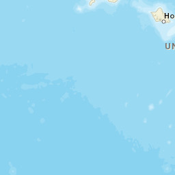


| Datetime (UTC) rmsOT_error |
Lat Smajor |
Lon Sminor |
D. (Km) AzErr |
Ndef mdist |
Nsta Mdist |
Gap | Mag1 (N) Err |
Mag2 (N) Err |
Mag3 (N) Err |
Author Quality |
|---|---|---|---|---|---|---|---|---|---|---|
| 2024-12-07T20:04:50.38Z 0.1+/- |
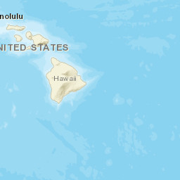
19.1448 3.46 |
-155.4933 1.63 |
27.5 3341.00999999 |
15 0.153 |
11 0.456 |
231.2 | md 2.8 (3) 0.26 |
() |
() |
HV a i ke |
| Sta | Dist | EvAz | Phase | Datetime | Tres | Azim | AzRes | Slow | SRes | Def | SNR | Amp | Per | Mag1 | Mag2 |
|---|---|---|---|---|---|---|---|---|---|---|---|---|---|---|---|
| KHU | 0.153 | 311.21 | P | 2024-12-07T20:04:55.68Z | 0.13 | ||||||||||
| KHU | 0.153 | 311.21 | S | 2024-12-07T20:04:59.4Z | -0.03 | ||||||||||
| DESD | 0.213 | 28.43 | S | 2024-12-07T20:05:00.27Z | 0.11 | ||||||||||
| AIND | 0.229 | 8.63 | P | 2024-12-07T20:04:56.46Z | 0.05 | ||||||||||
| HOVE | 0.243 | 274.79 | S | 2024-12-07T20:05:00.86Z | -0.14 | ||||||||||
| TRAD | 0.271 | 349.21 | P | 2024-12-07T20:04:56.88Z | 0.04 | ||||||||||
| CPKD | 0.293 | 33.13 | S | 2024-12-07T20:05:01.52Z | -0.2 | ||||||||||
| ELEP | 0.305 | 354.38 | P | 2024-12-07T20:04:57.28Z | 0.12 | ||||||||||
| ELEP | 0.305 | 354.38 | S | 2024-12-07T20:05:02.38Z | 0.13 | ||||||||||
| SDH | 0.308 | 37.64 | P | 2024-12-07T20:04:56.99Z | -0.07 | ||||||||||
| PUHI | 0.332 | 43.62 | P | 2024-12-07T20:04:57.35Z | 0 | ||||||||||
| PUHI | 0.332 | 43.62 | P | 2024-12-07T20:04:57.35Z | 0 | ||||||||||
| TOUO | 0.409 | 331.04 | P | 2024-12-07T20:04:58.21Z | -0.07 | ||||||||||
| HSSD | 0.456 | 1.22 | P | 2024-12-07T20:04:58.96Z | -0.1 | ||||||||||
| HSSD | 0.456 | 1.22 | S | 2024-12-07T20:05:05.5Z | -0.07 | ||||||||||
| Sta | Dist | EvAz | Phase | Datetime | Tres | Azim | AzRes | Slow | SRes | Def | SNR | Amp | Per | Mag1 | Mag2 |
| Centroid | Nodal Plan 1 | Nodal Plan 2 | Tensor | Moment Inf. | |||||||||||||||||
|---|---|---|---|---|---|---|---|---|---|---|---|---|---|---|---|---|---|---|---|---|---|
| Auth | Datetime | Lat | Lon | Depth | Mw | Strike | Dip | Rake | Strike | Dip | Rake | Mrr | Mtt | Mpp | Mrt | Mrp | Mtp | %DC | %ISO | %CLVD | |
| Auth | Datetime UTC | lat | lon | Depth | Mw | Strike | Dip | Rake | Strike | Dip | Rake | Mrr | Mtt | Mpp | Mrt | Mrp | Mtp | %DC | %ISO | %CLVD | |


