SeismicPortal
 is the European Infrastructure
 for seismological products in :
is the European Infrastructure 
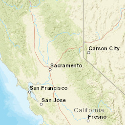


| Datetime (UTC) rmsOT_error |
Lat Smajor |
Lon Sminor |
D. (Km) AzErr |
Ndef mdist |
Nsta Mdist |
Gap | Mag1 (N) Err |
Mag2 (N) Err |
Mag3 (N) Err |
Author Quality |
|---|---|---|---|---|---|---|---|---|---|---|
| 2024-12-06T07:23:22.66Z 0.06+/- |
40.3085 6.84 |
-124.5132 1.78 |
20 2700.6600000260000001 |
10 0.132 |
10 83.891 |
244.8 | md 2.2 (9) 0.08 |
() |
() |
NC a i ke |
| Sta | Dist | EvAz | Phase | Datetime | Tres | Azim | AzRes | Slow | SRes | Def | SNR | Amp | Per | Mag1 | Mag2 |
|---|---|---|---|---|---|---|---|---|---|---|---|---|---|---|---|
| PETL | 0.132 | 98.89 | P | 2024-12-06T07:23:27.61Z | 0.37 | ||||||||||
| WLKR | 0.156 | 69.51 | P | 2024-12-06T07:23:27.6Z | 0.07 | ||||||||||
| B046 | 0.176 | 85.52 | P | 2024-12-06T07:23:27.61Z | -0.04 | ||||||||||
| KCT | 0.214 | 38.74 | P | 2024-12-06T07:23:27.62Z | -0.9 | ||||||||||
| B047 | 0.268 | 102.26 | P | 2024-12-06T07:23:29.8Z | 0.05 | ||||||||||
| KSM | 0.285 | 115.08 | P | 2024-12-06T07:23:29.21Z | -0.03 | ||||||||||
| RBOW | 0.309 | 84.95 | P | 2024-12-06T07:23:29.83Z | 0.02 | ||||||||||
| KMPB | 0.319 | 69.97 | P | 2024-12-06T07:23:29.79Z | -0.1 | ||||||||||
| KPR | 0.36 | 104.13 | P | 2024-12-06T07:23:30.63Z | -0.03 | ||||||||||
| GHOP | 0.409 | 90.12 | P | 2024-12-06T07:23:31.55Z | 0.08 | ||||||||||
| PRDS | 0.412 | 119.3 | P | 2024-12-06T07:23:31.3Z | -0.48 | ||||||||||
| BRIC | 0.511 | 112.39 | P | 2024-12-06T07:23:33.3Z | 0.06 | ||||||||||
| KMR | 0.625 | 99.53 | P | 2024-12-06T07:23:35.32Z | 0.56 | ||||||||||
| MNDO | 1.156 | 148.97 | P | 2024-12-06T07:23:41.25Z | -0.79 | ||||||||||
| LBK | 1.603 | 60.51 | P | 2024-12-06T07:23:47.9Z | -0.5 | ||||||||||
| LSH | 1.946 | 74.8 | P | 2024-12-06T07:23:53.35Z | -0.14 | ||||||||||
| SAGE | 1.946 | 74.74 | P | 2024-12-06T07:23:53.79Z | 0.62 | ||||||||||
| THOM | 83.891 | 33.8 | P | 2024-12-06T07:23:43.58Z | -1.08 | ||||||||||
| Sta | Dist | EvAz | Phase | Datetime | Tres | Azim | AzRes | Slow | SRes | Def | SNR | Amp | Per | Mag1 | Mag2 |
| Centroid | Nodal Plan 1 | Nodal Plan 2 | Tensor | Moment Inf. | |||||||||||||||||
|---|---|---|---|---|---|---|---|---|---|---|---|---|---|---|---|---|---|---|---|---|---|
| Auth | Datetime | Lat | Lon | Depth | Mw | Strike | Dip | Rake | Strike | Dip | Rake | Mrr | Mtt | Mpp | Mrt | Mrp | Mtp | %DC | %ISO | %CLVD | |
| Auth | Datetime UTC | lat | lon | Depth | Mw | Strike | Dip | Rake | Strike | Dip | Rake | Mrr | Mtt | Mpp | Mrt | Mrp | Mtp | %DC | %ISO | %CLVD | |

