SeismicPortal
 is the European Infrastructure
 for seismological products in :
is the European Infrastructure 


| Datetime (UTC) rmsOT_error |
Lat Smajor |
Lon Sminor |
D. (Km) AzErr |
Ndef mdist |
Nsta Mdist |
Gap | Mag1 (N) Err |
Mag2 (N) Err |
Mag3 (N) Err |
Author Quality |
|---|---|---|---|---|---|---|---|---|---|---|
| 2024-12-04T10:06:04.647511Z 0.3+/- 0.32 |
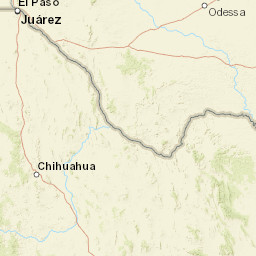
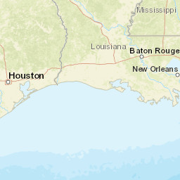
31.675 3 |
-104.103 2.12 |
4.1 46.978321075439451.27168536186218 |
38 0.028 |
20 1.164 |
81.2 | ml 2.1 (16) 0.2 |
() |
() |
TX a i ke |
| Sta | Dist | EvAz | Phase | Datetime | Tres | Azim | AzRes | Slow | SRes | Def | SNR | Amp | Per | Mag1 | Mag2 |
|---|---|---|---|---|---|---|---|---|---|---|---|---|---|---|---|
| PB23 | 0.028 | 113.2 | P | 2024-12-04T10:06:05.995Z | 0.105 | 498.5315095015464 | 0.007963167109198074 | ML 1.6297248140230294 | |||||||
| PB23 | 0.028 | 113.2 | S | 2024-12-04T10:06:06.865Z | 0.249 | ||||||||||
| PB34 | 0.055 | 88.23 | P | 2024-12-04T10:06:06.29Z | -0.112 | 652.2548874518978 | 0.016702854190662825 | ML 2.283392072654479 | |||||||
| PB34 | 0.055 | 88.23 | S | 2024-12-04T10:06:07.36Z | -0.142 | ||||||||||
| PB20 | 0.058 | 143.2 | P | 2024-12-04T10:06:06.491Z | 0.04 | 118.79093649548123 | 0.011721728408461932 | ML 2.1590831662823273 | |||||||
| PB31 | 0.084 | 47.18 | P | 2024-12-04T10:06:06.77Z | -0.163 | 789.5048815180405 | 0.015203869943313087 | ML 2.5333166194133554 | |||||||
| PB31 | 0.084 | 47.18 | S | 2024-12-04T10:06:08.23Z | -0.189 | ||||||||||
| PB24 | 0.091 | 127.18 | P | 2024-12-04T10:06:07.5Z | -0.05 | 281.24597894177714 | 0.005753682369887516 | ML 2.169249029339232 | |||||||
| PB24 | 0.091 | 127.18 | S | 2024-12-04T10:06:08.655Z | 0.025 | ||||||||||
| SA06 | 0.091 | 333.91 | P | 2024-12-04T10:06:07.63Z | 0 | 55.0561196871821 | 0.008018402947148976 | ML 2.3171155035192514 | |||||||
| SA06 | 0.091 | 333.91 | S | 2024-12-04T10:06:08.733Z | 0.089 | ||||||||||
| WB03 | 0.131 | 119.25 | P | 2024-12-04T10:06:07.7125Z | -0.081 | 106.66051619159707 | 0.003828856868647997 | ML 2.2871960379827807 | |||||||
| WB03 | 0.131 | 119.25 | S | 2024-12-04T10:06:10.25Z | 0.097 | ||||||||||
| PB40 | 0.148 | 102.82 | P | 2024-12-04T10:06:07.93Z | -0.173 | 40.9615786981355 | 0.0033998573059819065 | ML 2.3263923668657975 | |||||||
| PB40 | 0.148 | 102.82 | S | 2024-12-04T10:06:10.59Z | 0.149 | ||||||||||
| WB02 | 0.148 | 65.55 | P | 2024-12-04T10:06:07.9295Z | -0.179 | 14.126306126149188 | 0.001566332649827248 | ML 1.9911892327479352 | |||||||
| WB02 | 0.148 | 65.55 | S | 2024-12-04T10:06:10.3145Z | -0.132 | ||||||||||
| SA04 | 0.153 | 301.95 | P | 2024-12-04T10:06:08.199Z | 0.004 | 44.4507439448779 | 0.0003903636674502474 | ML 1.4075818217633178 | |||||||
| SA04 | 0.153 | 301.95 | S | 2024-12-04T10:06:10.789Z | 0.188 | ||||||||||
| CV01 | 0.175 | 3.9 | P | 2024-12-04T10:06:08.455Z | -0.164 | 103.09499119247593 | 0.0011610006370510724 | ML 1.9707646615070873 | |||||||
| CV01 | 0.175 | 3.9 | S | 2024-12-04T10:06:11.145Z | -0.189 | ||||||||||
| PB43 | 0.203 | 88.53 | P | 2024-12-04T10:06:08.85Z | -0.273 | 23.33521129170649 | 0.001133311370409758 | ML 2.0539932061794817 | |||||||
| PB43 | 0.203 | 88.53 | S | 2024-12-04T10:06:12.36Z | 0.155 | ||||||||||
| WB05 | 0.243 | 71.08 | P | 2024-12-04T10:06:10.4555Z | 0.59 | 21.332442524891412 | 0.0004120205780050716 | ML 1.7331330120879198 | |||||||
| WB05 | 0.243 | 71.08 | S | 2024-12-04T10:06:13.9455Z | 0.458 | ||||||||||
| PB13 | 0.25 | 118.75 | P | 2024-12-04T10:06:09.94Z | -0.052 | 33.14490269506078 | 0.000700734422164845 | ML 1.9821026478302082 | |||||||
| PB44 | 0.267 | 21.69 | P | 2024-12-04T10:06:10.965Z | -0.213 | 32.38095167876552 | 0.0012254174131945787 | ML 2.2689501930583136 | |||||||
| PB44 | 0.267 | 21.69 | S | 2024-12-04T10:06:14.5065Z | 0.251 | ||||||||||
| BP01 | 0.29 | 55.09 | P | 2024-12-04T10:06:11.8Z | 0.362 | 25.767990769718303 | 0.0008081193392127055 | ML 2.1408509821742068 | |||||||
| BP01 | 0.29 | 55.09 | S | 2024-12-04T10:06:14.87Z | -0.091 | ||||||||||
| SA07 | 0.293 | 310.51 | P | 2024-12-04T10:06:10.729Z | -0.064 | 15.335522218192363 | 0.0001743355515597203 | ML 1.484126890802633 | |||||||
| SA07 | 0.293 | 310.51 | S | 2024-12-04T10:06:14.789Z | -0.303 | ||||||||||
| PECS | 0.365 | 146.4 | P | 2024-12-04T10:06:12.3Z | -0.067 | 26.43039479093803 | 0.0004376972643003505 | ML 2.0278704199251347 | |||||||
| PECS | 0.365 | 146.4 | S | 2024-12-04T10:06:17.33Z | -0.016 | ||||||||||
| PB12 | 0.477 | 164.9 | P | 2024-12-04T10:06:14.17Z | 0 | 19.336154547594433 | 0.0004487561929910582 | ML 2.2196084592011824 | |||||||
| PB12 | 0.477 | 164.9 | S | 2024-12-04T10:06:20.12Z | -0.809 | ||||||||||
| VHRN | 1.164 | 220.71 | P | 2024-12-04T10:06:26.4Z | -0.057 | 4.239656594497571 | 0.0000526778845058997 | ML 1.880075916031819 | |||||||
| VHRN | 1.164 | 220.71 | S | 2024-12-04T10:06:43.17Z | 0.756 | ||||||||||
| Sta | Dist | EvAz | Phase | Datetime | Tres | Azim | AzRes | Slow | SRes | Def | SNR | Amp | Per | Mag1 | Mag2 |
| Centroid | Nodal Plan 1 | Nodal Plan 2 | Tensor | Moment Inf. | |||||||||||||||||
|---|---|---|---|---|---|---|---|---|---|---|---|---|---|---|---|---|---|---|---|---|---|
| Auth | Datetime | Lat | Lon | Depth | Mw | Strike | Dip | Rake | Strike | Dip | Rake | Mrr | Mtt | Mpp | Mrt | Mrp | Mtp | %DC | %ISO | %CLVD | |
| Auth | Datetime UTC | lat | lon | Depth | Mw | Strike | Dip | Rake | Strike | Dip | Rake | Mrr | Mtt | Mpp | Mrt | Mrp | Mtp | %DC | %ISO | %CLVD | |

