SeismicPortal
 is the European Infrastructure
 for seismological products in :
is the European Infrastructure 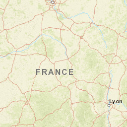


| Datetime (UTC) rmsOT_error |
Lat Smajor |
Lon Sminor |
D. (Km) AzErr |
Ndef mdist |
Nsta Mdist |
Gap | Mag1 (N) Err |
Mag2 (N) Err |
Mag3 (N) Err |
Author Quality |
|---|---|---|---|---|---|---|---|---|---|---|
| 2024-11-13T09:29:37.870384Z 0.66+/- 0.26 |
45.1033 |
3.9724 |
5 0 |
18 0.17 |
18 2.786 |
91.3 | ml 2 (13) 0.28 |
() |
() |
ReNaSS a i ke |
| Sta | Dist | EvAz | Phase | Datetime | Tres | Azim | AzRes | Slow | SRes | Def | SNR | Amp | Per | Mag1 | Mag2 |
|---|---|---|---|---|---|---|---|---|---|---|---|---|---|---|---|
| FR16A | 0.17 | 359.53 | P | 2024-11-13T09:29:41.19Z | -0.031 | ||||||||||
| SGSF | 0.257 | 257.57 | P | 2024-11-13T09:29:42.22Z | -0.598 | ||||||||||
| FR21A | 0.4 | 121.7 | P | 2024-11-13T09:29:45.26Z | -0.216 | ||||||||||
| COLF | 0.442 | 333.75 | P | 2024-11-13T09:29:46.17Z | -0.107 | ||||||||||
| FR22A | 0.473 | 194.93 | P | 2024-11-13T09:29:46.25Z | -0.573 | ||||||||||
| LBL | 0.529 | 284.33 | P | 2024-11-13T09:29:47.5Z | -0.378 | ||||||||||
| BALS | 0.691 | 212.6 | P | 2024-11-13T09:29:51.4Z | 0.156 | ||||||||||
| BANN | 0.745 | 169.83 | P | 2024-11-13T09:29:52.16Z | 0.26 | ||||||||||
| PLDF | 0.896 | 344.22 | P | 2024-11-13T09:29:54.62Z | -0.066 | ||||||||||
| OGDF | 0.952 | 124.61 | P | 2024-11-13T09:29:56.81Z | 1.069 | ||||||||||
| TRBF | 0.993 | 181.1 | P | 2024-11-13T09:29:56.53Z | -0.056 | ||||||||||
| FRNF | 1.034 | 286.3 | P | 2024-11-13T09:29:57.59Z | 0.321 | ||||||||||
| LEUC | 1.063 | 251.74 | P | 2024-11-13T09:29:57.48Z | -0.337 | ||||||||||
| FR17A | 1.213 | 272.58 | P | 2024-11-13T09:30:00.74Z | 0.49 | ||||||||||
| VERF | 1.231 | 302.15 | P | 2024-11-13T09:30:01.64Z | 1.15 | ||||||||||
| OGS3 | 1.299 | 90.82 | P | 2024-11-13T09:29:59.58Z | -1.83 | ||||||||||
| SLVF | 1.58 | 235.39 | P | 2024-11-13T09:30:05.15Z | -0.075 | ||||||||||
| REVF | 2.786 | 118.1 | P | 2024-11-13T09:30:22.432Z | 0.821 | ||||||||||
| Sta | Dist | EvAz | Phase | Datetime | Tres | Azim | AzRes | Slow | SRes | Def | SNR | Amp | Per | Mag1 | Mag2 |
| Centroid | Nodal Plan 1 | Nodal Plan 2 | Tensor | Moment Inf. | |||||||||||||||||
|---|---|---|---|---|---|---|---|---|---|---|---|---|---|---|---|---|---|---|---|---|---|
| Auth | Datetime | Lat | Lon | Depth | Mw | Strike | Dip | Rake | Strike | Dip | Rake | Mrr | Mtt | Mpp | Mrt | Mrp | Mtp | %DC | %ISO | %CLVD | |
| Auth | Datetime UTC | lat | lon | Depth | Mw | Strike | Dip | Rake | Strike | Dip | Rake | Mrr | Mtt | Mpp | Mrt | Mrp | Mtp | %DC | %ISO | %CLVD | |

