SeismicPortal
 is the European Infrastructure
 for seismological products in :
is the European Infrastructure 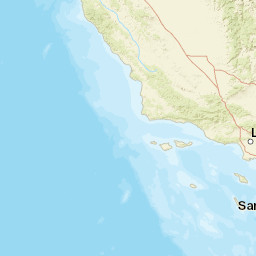


| Datetime (UTC) rmsOT_error |
Lat Smajor |
Lon Sminor |
D. (Km) AzErr |
Ndef mdist |
Nsta Mdist |
Gap | Mag1 (N) Err |
Mag2 (N) Err |
Mag3 (N) Err |
Author Quality |
|---|---|---|---|---|---|---|---|---|---|---|
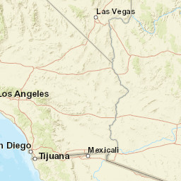
| 2024-11-07T16:40:18.2Z 0.11+/- |
33.1595 1.8 |
-115.9548 1.03 |
5.9 3370.74 |
13 0.024 |
11 1.906 |
101.1 | ml 2 (3) 0.72 |
() |
() |
SCSN a i ke |
| Sta | Dist | EvAz | Phase | Datetime | Tres | Azim | AzRes | Slow | SRes | Def | SNR | Amp | Per | Mag1 | Mag2 |
|---|---|---|---|---|---|---|---|---|---|---|---|---|---|---|---|
| PLR | 0.024 | 306.06 | P | 2024-11-07T16:40:19.42Z | -0.01 | ||||||||||
| 5375 | 0.179 | 268.94 | P | 2024-11-07T16:40:21.94Z | -0.02 | ||||||||||
| SWS | 0.25 | 148.66 | P | 2024-11-07T16:40:23.16Z | -0.14 | ||||||||||
| CRR | 0.272 | 182.51 | P | 2024-11-07T16:40:23.71Z | -0.05 | ||||||||||
| ACP | 0.357 | 235.2 | P | 2024-11-07T16:40:25.29Z | 0.11 | ||||||||||
| FRK | 0.359 | 47.57 | P | 2024-11-07T16:40:25.27Z | 0.1 | ||||||||||
| BOR | 0.402 | 285.73 | P | 2024-11-07T16:40:26.2Z | 0.26 | ||||||||||
| TOR | 0.473 | 331.37 | P | 2024-11-07T16:40:27.7Z | -0.1 | ||||||||||
| YUH2 | 0.511 | 176.89 | P | 2024-11-07T16:40:28.2Z | 0.29 | ||||||||||
| YUH2 | 0.511 | 176.89 | S | 2024-11-07T16:40:34.83Z | 0.16 | ||||||||||
| PMD | 0.602 | 324.12 | P | 2024-11-07T16:40:29.22Z | -0.18 | ||||||||||
| PMD | 0.602 | 324.12 | S | 2024-11-07T16:40:37.97Z | 0.73 | ||||||||||
| CYP | 0.619 | 246.06 | P | 2024-11-07T16:40:29.82Z | -0.06 | ||||||||||
| CORX | 1.318 | 236.07 | S | 2024-11-07T16:40:56.71Z | -2.4 | ||||||||||
| CFS | 1.455 | 310.76 | P | 2024-11-07T16:40:44.75Z | 0.67 | ||||||||||
| 13921 | 1.516 | 302.87 | P | 2024-11-07T16:40:44.97Z | 0.16 | ||||||||||
| GFF | 1.906 | 22.34 | P | 2024-11-07T16:40:49.97Z | -0.42 | ||||||||||
| GFF | 1.906 | 22.34 | S | 2024-11-07T16:41:16.77Z | 3.22 | ||||||||||
| Sta | Dist | EvAz | Phase | Datetime | Tres | Azim | AzRes | Slow | SRes | Def | SNR | Amp | Per | Mag1 | Mag2 |
| Centroid | Nodal Plan 1 | Nodal Plan 2 | Tensor | Moment Inf. | |||||||||||||||||
|---|---|---|---|---|---|---|---|---|---|---|---|---|---|---|---|---|---|---|---|---|---|
| Auth | Datetime | Lat | Lon | Depth | Mw | Strike | Dip | Rake | Strike | Dip | Rake | Mrr | Mtt | Mpp | Mrt | Mrp | Mtp | %DC | %ISO | %CLVD | |
| Auth | Datetime UTC | lat | lon | Depth | Mw | Strike | Dip | Rake | Strike | Dip | Rake | Mrr | Mtt | Mpp | Mrt | Mrp | Mtp | %DC | %ISO | %CLVD | |


