SeismicPortal
 is the European Infrastructure
 for seismological products in :
is the European Infrastructure 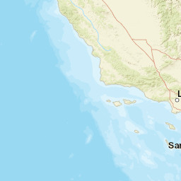


| Datetime (UTC) rmsOT_error |
Lat Smajor |
Lon Sminor |
D. (Km) AzErr |
Ndef mdist |
Nsta Mdist |
Gap | Mag1 (N) Err |
Mag2 (N) Err |
Mag3 (N) Err |
Author Quality |
|---|---|---|---|---|---|---|---|---|---|---|
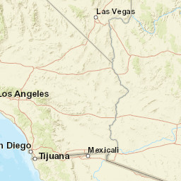
| 2024-11-06T03:31:57.72Z 0.16+/- |
33.769 8.16 |
-118.8417 1.63 |
10.6 3452.98 |
7 0.373 |
7 2.305 |
182.6 | ml 2 (36) 0.22 |
() |
() |
SCSN a i ke |
| Sta | Dist | EvAz | Phase | Datetime | Tres | Azim | AzRes | Slow | SRes | Def | SNR | Amp | Per | Mag1 | Mag2 |
|---|---|---|---|---|---|---|---|---|---|---|---|---|---|---|---|
| 5081 | 0.373 | 32.64 | P | 2024-11-06T03:32:03.7Z | -1.87 | ||||||||||
| NOT | 0.516 | 27.11 | S | 2024-11-06T03:32:14.62Z | -0.16 | ||||||||||
| CHI | 0.519 | 322.61 | P | 2024-11-06T03:32:07.67Z | -0.23 | ||||||||||
| MES | 0.536 | 336.87 | P | 2024-11-06T03:32:07.94Z | 0.04 | ||||||||||
| 25325 | 0.556 | 328.34 | P | 2024-11-06T03:32:08.51Z | 0.26 | ||||||||||
| FMO | 0.642 | 354.13 | P | 2024-11-06T03:32:10.28Z | 0.04 | ||||||||||
| 24730 | 0.669 | 20.74 | P | 2024-11-06T03:32:11.57Z | 1.37 | ||||||||||
| PASC | 0.677 | 53.51 | S | 2024-11-06T03:32:17.57Z | -1.57 | ||||||||||
| 23173 | 0.886 | 74.51 | S | 2024-11-06T03:32:25.57Z | 0.01 | ||||||||||
| QAD | 0.912 | 315.95 | P | 2024-11-06T03:32:14.34Z | -0.09 | ||||||||||
| ESI2 | 1.267 | 93.82 | P | 2024-11-06T03:32:21.78Z | 1.37 | ||||||||||
| MAN | 1.52 | 317.95 | P | 2024-11-06T03:32:21.65Z | -2.34 | ||||||||||
| LCP | 1.533 | 309.4 | S | 2024-11-06T03:32:43.96Z | -0.03 | ||||||||||
| 03121 | 1.683 | 126.76 | S | 2024-11-06T03:32:44.18Z | -2.68 | ||||||||||
| 03260 | 1.711 | 117.83 | P | 2024-11-06T03:32:25.54Z | -1.16 | ||||||||||
| EML | 1.887 | 117.11 | S | 2024-11-06T03:32:54.19Z | 2.77 | ||||||||||
| 12808 | 2.305 | 96.7 | P | 2024-11-06T03:32:38.85Z | 3.75 | ||||||||||
| Sta | Dist | EvAz | Phase | Datetime | Tres | Azim | AzRes | Slow | SRes | Def | SNR | Amp | Per | Mag1 | Mag2 |
| Centroid | Nodal Plan 1 | Nodal Plan 2 | Tensor | Moment Inf. | |||||||||||||||||
|---|---|---|---|---|---|---|---|---|---|---|---|---|---|---|---|---|---|---|---|---|---|
| Auth | Datetime | Lat | Lon | Depth | Mw | Strike | Dip | Rake | Strike | Dip | Rake | Mrr | Mtt | Mpp | Mrt | Mrp | Mtp | %DC | %ISO | %CLVD | |
| Auth | Datetime UTC | lat | lon | Depth | Mw | Strike | Dip | Rake | Strike | Dip | Rake | Mrr | Mtt | Mpp | Mrt | Mrp | Mtp | %DC | %ISO | %CLVD | |

