SeismicPortal
 is the European Infrastructure
 for seismological products in :
is the European Infrastructure 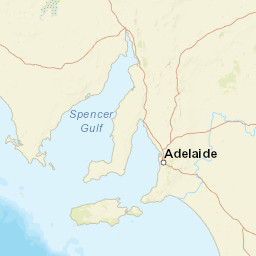

| Datetime (UTC) rmsOT_error |
Lat Smajor |
Lon Sminor |
D. (Km) AzErr |
Ndef mdist |
Nsta Mdist |
Gap | Mag1 (N) Err |
Mag2 (N) Err |
Mag3 (N) Err |
Author Quality |
|---|---|---|---|---|---|---|---|---|---|---|
| 2024-04-13T10:16:44.5Z 0.48+/- 0.3 |
-33.19 |
138.65 |
1 2 |
14 0.037 |
7 2.76 |
144.4 | mla 1.9 (6) 0.5 |
() |
() |
AUST m i ke |
| Sta | Dist | EvAz | Phase | Datetime | Tres | Azim | AzRes | Slow | SRes | Def | SNR | Amp | Per | Mag1 | Mag2 |
|---|---|---|---|---|---|---|---|---|---|---|---|---|---|---|---|
| AUJCS | 0.037 | 246.48 | P | 2024-04-13T10:16:45.2Z | -0.4 | MLa 2.27 | |||||||||
| AUJCS | 0.037 | 246.48 | S | 2024-04-13T10:16:45.7Z | 0.3 | MLa 2.27 | |||||||||
| HTT | 0.331 | 136.61 | P | 2024-04-13T10:16:50.6Z | -0.4 | MLa 1.24 | |||||||||
| HTT | 0.331 | 136.61 | S | 2024-04-13T10:16:54.9Z | -0.2 | MLa 1.24 | |||||||||
| NAPP | 0.421 | 270.81 | P | 2024-04-13T10:16:52.4Z | -0.4 | MLa 1.35 | |||||||||
| NAPP | 0.421 | 270.81 | S | 2024-04-13T10:16:58.2Z | 0.2 | MLa 1.35 | |||||||||
| YAPP | 1.351 | 347.71 | P | 2024-04-13T10:17:09.6Z | 0.2 | MLa 1.92 | |||||||||
| YAPP | 1.351 | 347.71 | S | 2024-04-13T10:17:27.8Z | 0.4 | MLa 1.92 | |||||||||
| SDAN | 1.433 | 156.64 | P | 2024-04-13T10:17:11.4Z | 0.6 | MLa 1.88 | |||||||||
| SDAN | 1.433 | 156.64 | S | 2024-04-13T10:17:30.1Z | 0.2 | MLa 1.88 | |||||||||
| BBOO | 2.21 | 279.17 | P | 2024-04-13T10:17:21.5Z | -0.8 | MLa 2.36 | |||||||||
| BBOO | 2.21 | 279.17 | S | 2024-04-13T10:17:50.7Z | -0.2 | MLa 2.36 | |||||||||
| LCRK | 2.76 | 352.19 | P | 2024-04-13T10:17:29.8Z | 0 | MLa 2.4 | |||||||||
| LCRK | 2.76 | 352.19 | S | 2024-04-13T10:18:04.8Z | 0.4 | MLa 2.4 | |||||||||
| Sta | Dist | EvAz | Phase | Datetime | Tres | Azim | AzRes | Slow | SRes | Def | SNR | Amp | Per | Mag1 | Mag2 |
| Centroid | Nodal Plan 1 | Nodal Plan 2 | Tensor | Moment Inf. | |||||||||||||||||
|---|---|---|---|---|---|---|---|---|---|---|---|---|---|---|---|---|---|---|---|---|---|
| Auth | Datetime | Lat | Lon | Depth | Mw | Strike | Dip | Rake | Strike | Dip | Rake | Mrr | Mtt | Mpp | Mrt | Mrp | Mtp | %DC | %ISO | %CLVD | |
| Auth | Datetime UTC | lat | lon | Depth | Mw | Strike | Dip | Rake | Strike | Dip | Rake | Mrr | Mtt | Mpp | Mrt | Mrp | Mtp | %DC | %ISO | %CLVD | |

