SeismicPortal
 is the European Infrastructure
 for seismological products in :
is the European Infrastructure 


| Datetime (UTC) rmsOT_error |
Lat Smajor |
Lon Sminor |
D. (Km) AzErr |
Ndef mdist |
Nsta Mdist |
Gap | Mag1 (N) Err |
Mag2 (N) Err |
Mag3 (N) Err |
Author Quality |
|---|---|---|---|---|---|---|---|---|---|---|
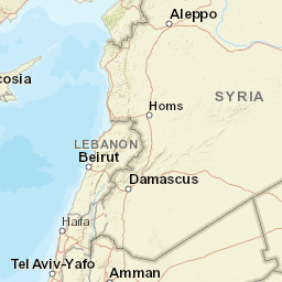
| 2024-04-13T08:24:31.8Z +/- |
36.4572 |
38.373 |
9.6 |
6 1.045 |
5 2.055 |
249.4 | ml 2 () |
() |
() |
KOERI m i ke |
| Sta | Dist | EvAz | Phase | Datetime | Tres | Azim | AzRes | Slow | SRes | Def | SNR | Amp | Per | Mag1 | Mag2 |
|---|---|---|---|---|---|---|---|---|---|---|---|---|---|---|---|
| URFA | 1.045 | 19.94 | Pg | 2024-04-13T08:24:52.3Z | 0 | ||||||||||
| URFA | 1.045 | 19.94 | Sg | 2024-04-13T08:25:07.2Z | 0 | ||||||||||
| GAZ | 1.175 | 307.74 | Pn | 2024-04-13T08:24:54.7Z | 0 | ||||||||||
| KMRS | 1.576 | 312 | Pn | 2024-04-13T08:25:00.6Z | 0 | ||||||||||
| MAZI | 1.939 | 58.34 | Pn | 2024-04-13T08:25:05.7Z | 0 | ||||||||||
| SVRC | 2.055 | 20.91 | Pn | 2024-04-13T08:25:07.5Z | 0 | ||||||||||
| Sta | Dist | EvAz | Phase | Datetime | Tres | Azim | AzRes | Slow | SRes | Def | SNR | Amp | Per | Mag1 | Mag2 |
| Centroid | Nodal Plan 1 | Nodal Plan 2 | Tensor | Moment Inf. | |||||||||||||||||
|---|---|---|---|---|---|---|---|---|---|---|---|---|---|---|---|---|---|---|---|---|---|
| Auth | Datetime | Lat | Lon | Depth | Mw | Strike | Dip | Rake | Strike | Dip | Rake | Mrr | Mtt | Mpp | Mrt | Mrp | Mtp | %DC | %ISO | %CLVD | |
| Auth | Datetime UTC | lat | lon | Depth | Mw | Strike | Dip | Rake | Strike | Dip | Rake | Mrr | Mtt | Mpp | Mrt | Mrp | Mtp | %DC | %ISO | %CLVD | |

