SeismicPortal
 is the European Infrastructure
 for seismological products in :
is the European Infrastructure 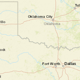


| Datetime (UTC) rmsOT_error |
Lat Smajor |
Lon Sminor |
D. (Km) AzErr |
Ndef mdist |
Nsta Mdist |
Gap | Mag1 (N) Err |
Mag2 (N) Err |
Mag3 (N) Err |
Author Quality |
|---|---|---|---|---|---|---|---|---|---|---|
| 2023-12-10T09:14:13.937137Z 1.04+/- 0.29 |
34.3187 2996.99 |
-97.5197 2303.88 |
0.6 131.59790521.611424569 |
50 0.059 |
28 2.232 |
68.3 | ml 2.1 (9) 0.31 |
() |
() |
OK a i ke |
| Sta | Dist | EvAz | Phase | Datetime | Tres | Azim | AzRes | Slow | SRes | Def | SNR | Amp | Per | Mag1 | Mag2 |
|---|---|---|---|---|---|---|---|---|---|---|---|---|---|---|---|
| SC04 | 0.059 | 220.49 | P | 2023-12-10T09:14:14.879999Z | -0.4 | ML 2.195685281 | |||||||||
| SC04 | 0.059 | 220.49 | S | 2023-12-10T09:14:16.699999Z | 1.294 | ||||||||||
| WADE | 0.188 | 25.94 | P | 2023-12-10T09:14:17.494999Z | -0.237 | ML 2.65201771 | |||||||||
| WADE | 0.188 | 25.94 | S | 2023-12-10T09:14:21.334999Z | 1.667 | ||||||||||
| SC09 | 0.259 | 209.4 | P | 2023-12-10T09:14:18.459999Z | -0.615 | ML 2.027849961 | |||||||||
| SC09 | 0.259 | 209.4 | S | 2023-12-10T09:14:23.159999Z | 1.159 | ||||||||||
| X34A | 0.383 | 137.32 | P | 2023-12-10T09:14:21.49999Z | -0.357 | ML 2.267025886 | |||||||||
| X34A | 0.383 | 137.32 | S | 2023-12-10T09:14:27.569999Z | 1.517 | ||||||||||
| LOOK | 0.431 | 319.25 | P | 2023-12-10T09:14:22.439999Z | 0.122 | ML 2.618586228 | |||||||||
| LOOK | 0.431 | 319.25 | S | 2023-12-10T09:14:25.949999Z | -1.687 | ||||||||||
| SC02 | 0.49 | 192.74 | P | 2023-12-10T09:14:22.684999Z | -0.76 | ||||||||||
| SC02 | 0.49 | 192.74 | S | 2023-12-10T09:14:29.994999Z | 0.401 | ||||||||||
| SC14 | 0.614 | 102.31 | P | 2023-12-10T09:14:24.98Z | -0.808 | ML 1.97024024 | |||||||||
| SC13 | 0.625 | 229.4 | P | 2023-12-10T09:14:25.94999Z | -0.916 | ML 2.086341771 | |||||||||
| SC13 | 0.625 | 229.4 | S | 2023-12-10T09:14:34.174999Z | 0.121 | ||||||||||
| FNO | 0.941 | 185.99 | P | 2023-12-10T09:14:30.734999Z | -1.266 | ||||||||||
| FNO | 0.941 | 185.99 | S | 2023-12-10T09:14:43.894999Z | -0.567 | ||||||||||
| WTFS | 0.959 | 54.66 | P | 2023-12-10T09:14:31.68Z | -0.649 | ||||||||||
| WTFS | 0.959 | 54.66 | S | 2023-12-10T09:14:44.425Z | -0.608 | ||||||||||
| W35A | 0.988 | 212.76 | P | 2023-12-10T09:14:31.495Z | -1.371 | ||||||||||
| W35A | 0.988 | 212.76 | S | 2023-12-10T09:14:42.905Z | -3.061 | ||||||||||
| SC20 | 1.321 | 144.73 | P | 2023-12-10T09:14:37.45Z | -0.9 | ||||||||||
| FW06 | 1.343 | 1.32 | P | 2023-12-10T09:14:39.3625Z | 0.648 | ||||||||||
| ARC2 | 1.436 | 188.21 | P | 2023-12-10T09:14:39.135Z | -1.049 | ||||||||||
| ARC2 | 1.436 | 188.21 | S | 2023-12-10T09:14:59.335Z | -0.026 | ||||||||||
| DUST | 1.506 | 230.84 | P | 2023-12-10T09:14:41.49Z | 0.193 | ||||||||||
| DUST | 1.506 | 230.84 | S | 2023-12-10T09:15:01.33Z | -0.065 | ||||||||||
| FW07 | 1.627 | 7.79 | P | 2023-12-10T09:14:44.945Z | 0.908 | ||||||||||
| SC12 | 1.629 | 111.16 | P | 2023-12-10T09:14:42.425Z | -0.778 | ||||||||||
| SC12 | 1.629 | 111.16 | S | 2023-12-10T09:15:04.735Z | -0.138 | ||||||||||
| PLPT | 1.642 | 23.66 | P | 2023-12-10T09:14:42.725Z | -0.696 | ||||||||||
| DRIP | 1.759 | 223.19 | P | 2023-12-10T09:14:44.965Z | -0.235 | ||||||||||
| DRIP | 1.759 | 223.19 | S | 2023-12-10T09:15:09.345Z | 0.833 | ||||||||||
| RNSP | 1.773 | 155 | P | 2023-12-10T09:14:45.214999Z | -0.211 | ||||||||||
| RNSP | 1.773 | 155 | S | 2023-12-10T09:15:09.384999Z | 0.462 | ||||||||||
| HTCH | 1.821 | 158.3 | P | 2023-12-10T09:14:45.975Z | -0.159 | ||||||||||
| HTCH | 1.821 | 158.3 | S | 2023-12-10T09:15:10.475Z | 0.263 | ||||||||||
| WILB | 1.867 | 250.93 | P | 2023-12-10T09:14:48.59Z | 1.764 | ||||||||||
| WILB | 1.867 | 250.93 | S | 2023-12-10T09:15:12.93Z | 1.461 | ||||||||||
| QUIN | 1.905 | 243.02 | P | 2023-12-10T09:14:46.815Z | -0.574 | ||||||||||
| QUIN | 1.905 | 243.02 | S | 2023-12-10T09:15:13.625Z | 1.132 | ||||||||||
| SC15 | 2.074 | 127.73 | P | 2023-12-10T09:14:50.245Z | 0.433 | ||||||||||
| SC15 | 2.074 | 127.73 | S | 2023-12-10T09:15:19.435Z | 2.561 | ||||||||||
| PW10 | 2.119 | 195.61 | P | 2023-12-10T09:14:49.98Z | -0.454 | ||||||||||
| STIG | 2.232 | 243.5 | P | 2023-12-10T09:14:53.554999Z | 1.554 | ||||||||||
| STIG | 2.232 | 243.5 | S | 2023-12-10T09:15:22.524999Z | 1.715 | ||||||||||
| Sta | Dist | EvAz | Phase | Datetime | Tres | Azim | AzRes | Slow | SRes | Def | SNR | Amp | Per | Mag1 | Mag2 |
| Centroid | Nodal Plan 1 | Nodal Plan 2 | Tensor | Moment Inf. | |||||||||||||||||
|---|---|---|---|---|---|---|---|---|---|---|---|---|---|---|---|---|---|---|---|---|---|
| Auth | Datetime | Lat | Lon | Depth | Mw | Strike | Dip | Rake | Strike | Dip | Rake | Mrr | Mtt | Mpp | Mrt | Mrp | Mtp | %DC | %ISO | %CLVD | |
| Auth | Datetime UTC | lat | lon | Depth | Mw | Strike | Dip | Rake | Strike | Dip | Rake | Mrr | Mtt | Mpp | Mrt | Mrp | Mtp | %DC | %ISO | %CLVD | |
